May 3, 2008 | 7:45 AM
Category:
Weather
Sunday evening…a complete weather update is being included
at the end of this original blog entry…
I thought you might be interested in the script that I put together for our report last night concerning the Greensburg tornados and what would happen if those same twisters hit KC...the story we ran last night was somewhat condensed but still 6 minutes long...the story that airs tomorrow is the "directors" cut...with an addition 1+ minute of other information...I put the script here and highlighted the words/sections in red that got cut out...I thought you might find it interesting to see the editing process that's done in order to fit things into a time frame....some cuts that were asked of me...I didn't agree with and won those arguments...but saving one part means sacrificing another part...if you want to see all the information concerning my story plus web exclusives go to our
dedicated Greensburg page (click it)...it's the only one of it's kind and you can actually see if your home would've been hit in the scenario laid out...feel free to leave a comment or just send me an email at
[email protected] with any questions or reactions. You can thank Whitney, our web producer and all around good person for putting together an
EXCELLENT page with lots of exclusive content stuff!
Script startsBy now you seen the pictures…whether from the ground….or from the air thanks to Skyfox…most of Greensburg, KS wiped away by a massive EF5 tornado with winds at least 200 MPH.
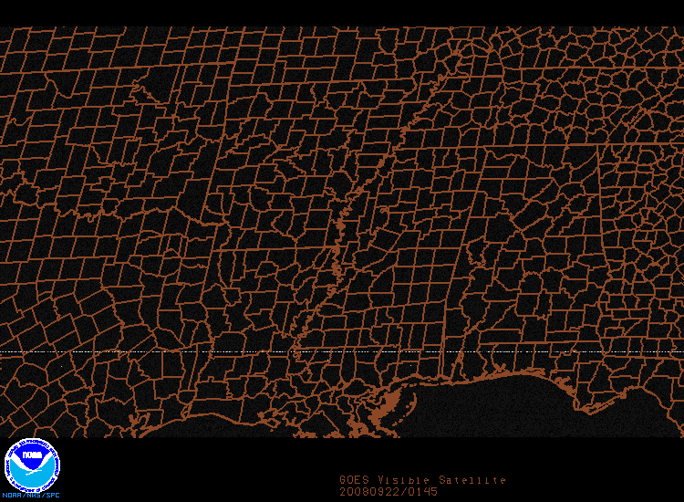
There were more than 20 tornados that night, including 4 that are referred to as the "Big 4", the 1st of which hit Greensburg. Here is a look at the radar from that destructive night…the familiar hook echoes, radar's tornado signature, constantly show up in the data. But what would've happened if those 4 tornados, instead of hitting a more rural area of KS…instead brought their wrath into a big city…like Kansas City
Now granted the conditions that led to those huge storms occur infrequently for large metropolitan areas, like Kansas C"Now granted the conditions that led to those huge storms ity, and while it seems these things always target the rural areas, as cities like KC grow outwards…the odds of a devastating tornado hitting a large city go up and up every year."
About 6 weeks ago Atlanta, GA was struck by an EF2 tornado…that actually went right through downtown Atlanta. It's a scenario that has at least one local emergency manager concerned…
"I think it's something that we plan for and will happen at some point in the future...so it does happen from time to time. I think it's more of a statisical probability than anything that magically protects a metropolitan area"
Why be worried…let me show you…check out the town of Greensburg before the tornado….now afterwards. So what would happen if those same tornados with the exact same tracks struck the KC metropolitan area…how would we have fared from that devastating night… Tornado #1…The Greensburg tornado would've hit JO CO hard.
"Tornado #1 would've developed on the Johnson/Miami county line and for about 15 miles slowly would've churned its way up I-35 as it approached one very familiar landmark."
"As a matter of fact, its right here @ I-35 and Quivera that the tornado would've been 1 mile and three quarters wide…right across the street from Oak Park Mall."
All totaled that tornado would've been on the ground destroying homes, apartments and businesses in JO CO for 29 miles…
Scott Perkins of Western Air Maps used some census software to determine how many homes and people would've been in the path of the Greensburg Tornado if it were to hit here…."the valuation of property damage as well as personal property damage is a little over 4 billion dollars in valuation with 78,000 people potentially affected depending on the time of day."
Here's where the big differences lie…In Greensburg some 1500 homes and businesses were damaged or destroyed valued at 250 million dollars…that same tornado with the exact same track…in this scenario would've hit more than 29,000 homes and businesses in Johnson County
But that was just 1 of 4 big storms. The second could've been even worse and that's why we're up in SKYFOX…that would've touched down right near I-35…just south Shawnee Mission Parkway and come right through the heart of Kansas City. That would've been an EF3 tornado and would've stayed on the ground for 24 miles moving through downtown KC…the KC rail yards…and most of north KC…and at one point would've been more than 2 miles across…even wider than the Greensburg tornado…churning away for over an hour.
What is so disturbing about that tornado is that while estimates of the winds were close to 150 MPH…the reality is that it was probably even stronger…
that's because in rural Kansas it occurred in wide open country and a true wind analysis was hard to come by. "This would be a catastrophe, preparing for a catastrophe like this is difficult. These are very rare events and if it did happen in KC the circumstances would be grave I have to say."
Not only would virtually every downtown building north of Liberty Memorial suffered some damage or in some cases been destroyed, but an environmental disaster could occur as well.
"Certainly a direct strike by a tornado would be enough to dislodge a railcar if not pick it up and so what contents are in that car could be spilled and if it's a chemical, liquid or gas could affect population in that area"
This second tornado last year did only 1.5 million dollars in damage affecting very few homes…place that same tornado on top of downtown KC…and the damage to houses and apartments alone would be more than 2 and a half billion dollars because almost 34,000 homes would've been hit.
That doesn't include all the businesses, 3 hospitals and 27 schools that could've been destroyed.That second tornado would've happened at night...but what would've happened if it occurred in the late in the afternoon.
"But I think a scenario like this would be worse during during rush hour. You've got people in traffic, they've got nowhere to go...they're in cars very vulnerable to tornados
and so we might have many casualties just based on that but the city would certainly be in a crisis mode and take years to recover."There were also 2 other tornados that while not as strong also would've hit some of the communities just east of downtown KC hard….such as the Sugar Creek area…River Bend...the outskirts of Liberty and near Kearney…
The final tallies are staggering…using that census data…all told about 65,000 homes would've been damaged if not destroyed in the metropolitan area directly impacting 157000 people…or 8% of the KC population…and remember it's not just houses that would've suffered….apartments, businesses, hospitals and schools all would've had damage from ripped roofs to total destruction. The initial damage value based on 2000 census data…shows a potential 7 billion dollar price tag but that incredible value doesn't include any of the damage to almost 4,000 commercial or business structures that would've been in the path of those 4 twisters. That damage plus shut downs, layoffs and lost business would potentially have cost billions more. No doubt an area wide disaster that would've taken years to recover from…
"being from here and living in a lot of different places across the country in California and Arizona, I've seen natural disasters and I've seen the numbers that come rolling through but the amount of valuation from personal residential property is staggering…I wasn't expecting to find that much."
Now remember that 7 billion dollar estimate is based on personal property construction through 2000…and doesn't take into account the billions of dollars in commercial property destruction …especially in the downtown area…think about all the condo development that's occurred and yes…even the brand spanking new Sprint Center, the new federal building…the new HR Block building all targets of those devastating tornados.It's a scenario that hopefully we'll never go through but one that emergency managers, FEMA and government agencies need to think about, if not plan
for and in the world of weather 275 miles is not that big of a deal…that's the distance between here and Greensburg, KS.
So would your neighborhood have been directly affected by any of the Big 4 tornados that hit out west last year. We invite you to go to our website at myfoxkc.com. We've overlayed the exact tracks those 4 tornados took on a map of Kansas City so you can see whether or not your house, neighborhood or community would've been hit on that historic night.
end script
OK lets talk weather…today is a fascinating day in weather
history…last year the Greensburg tornado hit…5 years ago the Northland was
struck hard…and 9 years ago yesterday Oklahoma City (Moore) was hit by a F5
tornado…by the way up until Greensburg that was the last “5” classification…
I bring this all up because as you know…up until 2003 the KC
area had pretty much been spared devastating tornados…sure there was Ruskin
Heights and a couple of others in ’79 I believe but overall we typically didn’t
have to deal with tornado outbreaks…and it got me thinking….
How would we cover these situations…none of us really dealt
professionally with this on the air…sure there were warnings every year…but in
terms of concrete stuff…not so much. After Moore, OK was devastated a couple of
stations (KFOR and KOCO I think) came out with video tapes of there coverage
and the aftermath…I believe in an effort to raise money for the victims and the
recovery process…we obtained those tapes and I watched them intently…I was
impressed by the calmness displayed and the professionalism and mainly the
chopper shots…with that as a reference we covered the Northland tornado
outbreak.
This was a no-brainer…several days before we could see it
coming…did we know exactly where the worse would be…no but the potential was
screaming. The day before on the air I conveyed the seriousness of the
situation…so much so that I received a couple of emails complaining that I was “hyping”
a situation which is soooo not me.
From a staffing standpoint we had our ducks in a row because
we just knew. Here’s the thing though and this is only my opinion…but I really
feel that up till then when people heard the sirens…heard about the warnings
previously…they started to really feel apathy towards the situation at hand….and
I can’t blame the general population for those feelings…5…10…15 years go by…warnings
come and go…sirens blare and blare and the end result is no damage to YOUR OWN
HOME. Those that have felt the direct impacts in previous times didn’t feel
that way…by for the metro at large…it had been soooo long.
Covering the storms was surreal. I can’t speak about my
colleagues reactions but I’m sure they were just as stunned by the actual
events…when we took those first exclusive SKYFOX shots with DH showing the
unfolding tornado developing and showing the devastation with in seconds of its
occurrence…it was shocking. Then I remembered the coverage from OK 4 years
earlier…keep the chopper shots for as long as possible…radar is great and we
used it extensively…but the bottom line is to many people (weather nerds J)
excluded, the colors are just blobs…but when you have pictures/videos of what
is happening…it’s the most compelling TV imaginable. People then understand the
situation. You show a mile wide tornado on the air…and people will watch it.
Now before you think that we’re just patting ourselves ALL the stations did an
outstanding job…everybody was watching one of the 4 local stations that
afternoon/evening…ALL my colleagues help to save lives that day…ALL the
stations received emotional emails from viewers saying something to the effect
of “thanks for saving our lives” etc. It was by far one of the most satisfying
professional days of my live. Sadly seeing all the destruction was humbling but
from a coverage standpoint I’m not aware that any meteorologist out there could’ve
done any better than what the 4 stations did that day in KC. Ironically that
was 5 days after one of the lowest career days of my life…when we didn’t do a
good job in a severe weather situation…at least in the viewers eyes…that story
for another time…
OK now this week…no issues tomorrow…mid if not upper 70s
with clouds moving into the area especially in the PM…atmosphere starting to
saturate tomorrow night…
TUE I’m expecting scattered showers/t-showers…not a rainout
but more of an appetizer of potentially what’s coming…
WED may at times be very wet…dewpoints towards the gulf
coast are in the lower 70s…2-3 days of south winds means that a lot of moisture
is heading our way. The storm is on the water vapor loop and when it ejects
into the plains on WED…severe weather is possible for some…flooding rainfall
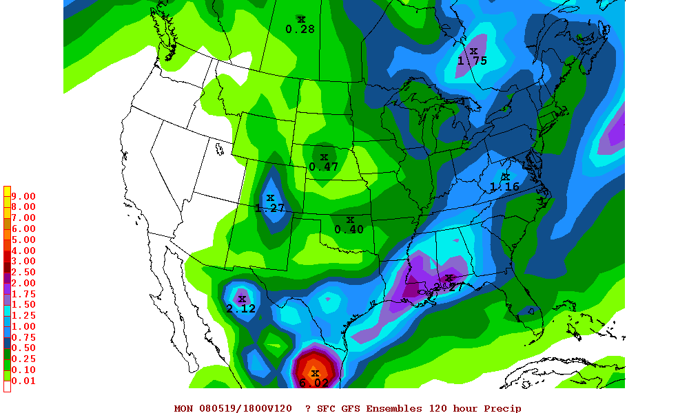
for others…and in some cases both. The GFS(E) is wet! Here is the 5 day totals...keep in mind that the ensembles average the output of all the variable runs of the same model...it tends to smooth things out...
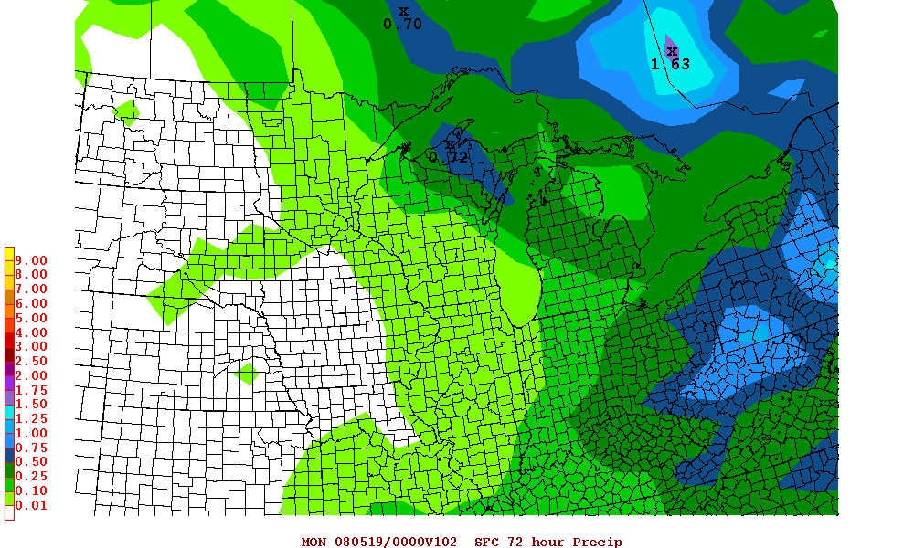
The GFS is crazy wet. Here is the 72 hour total from 7PM MON-7PM THU...
Now
the exact placement of the heaviest rain axis is impossible to figure from so
far out…actually it may even be tough on WED because various mesoscale
processes will complicate the atmosphere’s set-up. Suffice it to say…make sure
the sump pump is primed and ready…somewhere in our viewing area inches of
rainfall are possible…we’ll have to get closer to figure things out.
Have a great weekend...thanks for all the good responses to my story via email!
Joe
May 2, 2008 | 5:33 PM
Category:
Weather
THE WEATHER SPECIAL IS SCHEDULED FOR TONIGHT...I'VE HEARD FROM DOZENS OF EMERGENCY MANAGERS CURIOUS ABOUT THE DATA THAT WE'LL BE REVEALING TO YOU. HOWEVER...WE'RE ALTERING THE SHOW A BIT TO TAKE INTO ACCOUNT THE EVENTS LAST NIGHT...WE'LL BE REDOING OUR WEATHER ROUND TABLE AND TALKING ABOUT VARIOUS ASPECTS OF THE EVENTS OF LAST NIGHT. SOME OF THE ELEMENTS THAT WERE SUPPOSED TO BE IN THE SHOW WILL BE SHOWN OVER THE COURSE OF NEXT WEEK...
Well that was an adventure...lots of coverage...lots of damage and now the NWS has confirmed that we were dealt 2 tornados...one an EF2 and another an EF3...an EF2 tornado has 111 and 135 MPH while an EF3 has winds 136-165 MPH...damage is obvious and I invite you to go the the home page and look at SKYFOX video for a sense of what happened.
Numerous emails thanking us for all the coverage...as usual some emails condemning the coverage...even in the middle of the night. It is what it is...never perfect but when you see the damage and you hear from viewers you realize that you hopefully made the right decision.
I got to bed around 5:30 this AM got a few hours sleep then back up and headed to Kearney where apparently most of the school was watching our coverage because when I walked in I got a standing ovation. Talk about a great way to start a safety speech when the batteries are a bit on the low side...so thanks to Hawthorne Elementary...
The severe weather now is moving towards the TN Valley...TOR warnings in effect around and east of the Memphis area...
Concerning last night...some residents are complaining about the lack of siren warnings...keep in mind
in most cases sirens are set off only for TORNADO WARNINGS...I've seen very few exceptions...one of which was several years ago when in the middle of the night 90-100 mph winds were in Independence I believe...the NWS realized the danger and, if memory serves, asked EM to trigger the sirens...or EM decided on their own to trigger...anyway it happens
very rarely that non-TOR warned storms get the siren activation.
The tornados that touched down apparently were on the ground for 1-2 minutes a piece...they were moving at 60 mph...they were embedded with this mass of rain that had front side winds of, in many cases, well over 60 mph. Despite the dozens of times last night that we talked about the seriousness of the wind...how the winds that were moving in were going to be in most cases stronger than many weak tornados that form...there is still a mind thing that, since we've been through these events so many times in the past, that perhaps there is a tendency to, not ignore, but perhaps worry a bit less on what these winds can do. Now that
wasn't the angle we took on the air...I remember mentioning several times at whatever hour in the AM it was...that I hadn't remembered such a large potentially damaging bow echo, from a radar standpoint, that was going to affect this area in a long time...it was so impressive coming into Topeka's radar range and we knew by about 11:30 or so that we were going to be on the air for a longggggg time in a couple more hours. if you watched MT and myself last night...MT must've mentioned about 20 times the potential of some spin ups on the northern side of this bow echo...
One of the things that I remembered about last night was the retreating dry line...I remember this happening often in West TX when I worked down there a while back...they were fascinating things to observe...the last time I remember it here was 3/12/06...another big severe weather day in the region...all sorts of TOR warnings...then it settled down in the late PM...then the dry line started to retreat...new storms fired to the SE of here...and tornados formed...another crazy day/night...lesson be aware and wary of retreating dry lines in this part of the country...
Concerning the NWS...I think they did fantastic for the entire event...the
strong wording in their statements..talking about
HURRICANE force winds bearing down on the metro was accurate and well timed...warnings (not tornado) were issued.... in retrospect odds are the tornados that came down very possibly were in between scans...they lasted for less than 2 minutes...if you're scanning a storm every 5 minutes or so...it can happen. Now if we were expecting only 40-50 mph winds...that's a different story but we were constantly talking about the higher wind threat associated with this feature. The science of radar is only so good...
Tornado warnings that verified were the Clinton county storm and the northern Cass county storm...both EF0...
TORNADOES CONFIRMED IN CASS AND CLINTON COUNTIES...
THE NATIONAL WEATHER SERVICE IN PLEASANT HILL IN CONJUNCTION WITH
EMERGENCY MANAGEMENT HAS CLASSIFIED SEVERE WEATHER DAMAGE WAS
PRODUCED BY TORNADOES IN PLATTSBURG...CLINTON COUNTY AND
NORTHWESTERN CASS COUNTY NEAR BELTON. BOTH OF THESE TORNADOES
PRODUCED DAMAGE THAT WARRANTED AN EF-0 RATING...WHICH IS
CHARACTERIZED BY WINDS THAT INCLUDE A THREE SECOND GUST BETWEEN 65
AND 85 MPH.We talked a lot about bow echoes last night...here is a good explainer if your interested...
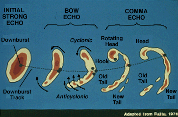 Squall lines
 and
multicell storms
occasionally develop the appearance of
a "bow echo" on radar. When the bow shape opens toward the strong mid-level
winds (10 to 20 thousand foot level winds of 40 knots or greater), there is an
excellent chance that the strong mid-level currents have been transported to the
ground in a
downburst,
forcing a portion of the squall line or multicell storm
to accelerate forward.
Macroburst and
microburst
winds are common with these
storms, and 100+ MPH winds have been reported in extreme cases.
Weak
to occasionally
strong
tornadoes may occur with the comma head,
while gustnadoes may form on the
strong bow echo
gust front. The bow echo weakens as the accelerating downburst
outruns the storm complex. Those who
operate radar should be aware that the
rotating comma head occasionally has
deceptively weak radar reflectivity while producing damaging winds and
tornadoes. (source: University Of Illinois).
That's it for now...we'll get more into the story that airs tonight...tomorrow on the blog. For the latest forecast check with MT this evening...
Joe
May 1, 2008 | 10:48 PM
Category:
Weather
We're all taking a breathe now...will effort some graphics showing the local storm reports...our thanks to the spotters/chasers/SKYFOX et al for helping with coverage tonight.
Reminder about the weather special tomorrow @ 9:30 PM
More storms to the south of the metro...they are in unaltered air from tonights convection...there are signs of rotation...so these will effect areas to the SE of KC for the next several hours...
Also new storms associated with a retreating dryline/catching up cold front. Notice how the dewpoint in Topeka has shot up from the lower 40s to the upper 50s on a SE wind...so the convergence will be increasing overnight. A new meso came out that seems to indicate another watch of some sort will be issued later tonight...
Reports through about 11PM or so
joe
May 1, 2008 | 5:18 PM
Category:
Weather
Well if you've been tracking the developments of today through the data this AM...things are coming together as expected...essentially we are capped for the time being in the metro and points east but the cap will be weakening over the next several hours...and SKYFOX is reporting that there are some towering cumulus starting to sprout up well out towards the west AND STORMS ARE RAPIDLY DEVELOPING NOW!
There is a weak dryline just west of the metro...and a few echoes are showing up now just east of Emporia which is where there is chaser convergence now as well as south of there...
However the cap will gradually break down over the next 6 hours or so from west to east and t/storms should erupt along one or more boundries before midnight. You can track the cap via the 10K temperatures...you'll notice over the next 6 hours our temps dropping from from near 10C at that level to around 5 or so towards midnight...SPC just came out with a meso discussion...targeting our region...
ALTHOUGH ISOLATED TSTM DEVELOPMENT IS POSSIBLE THROUGH 00Z...MORE PROBABLE INITIATION APPEARS LIKELY BETWEEN 00-03Z AS STRONGER
LARGE-SCALE ASCENT AND COLD FRONT OVERTAKE THE DRYLINE.
STRENGTHENING LOW/MID-LEVEL SHEAR WILL PROVE FAVORABLE FOR
SUPERCELLS INITIALLY LIKELY GROWING UPSCALE INTO A QUASI-LINEAR CONVECTIVE SYSTEM LATER THIS EVENING. LARGE HAIL /SOME POSSIBLY
SIGNIFICANT/...DAMAGING WINDS...AND ISOLATED TORNADOES SHOULD OCCUR.
A WW WILL LIKELY BE REQUIRED.
RECENT VIS SATELLITE IMAGERY INDICATE DEEPENING CU FIELD ALONG THE
DRYLINE FROM AROUND 20 E PNC TO STJ. 21Z TOP RAOB DEPICTED NEARLY
COMPLETE REMOVAL OF CAPPING INVERSION...EVEN WITH SURFACE DEW POINTS
IN THE LOWER 50S SAMPLING JUST W OF DRY LINE. MODIFYING FOR LOWER
60S DEW POINTS WITHIN THE MOIST SECTOR YIELDS A MODERATE TO STRONGLY
UNSTABLE AIR MASS WITH MLCAPES OF 2000 TO 3000 J/KG. STILL WITH ONLY
MODEST ASCENT ALONG THE DRY LINE ATTM...THERE IS UNCERTAINTY AS TO
THE EXTENT OF CONVECTIVE GROWTH PRIOR TO 00Z.
TSTM DEVELOPMENT APPEARS MORE PROBABLE AFTER 00Z AS STRONGER FORCED
ASCENT SPREADS EWD /AS INDICATED BY HIGH-BASED CONVECTION OVER SWRN
KS/...AND AS SURFACE COLD FRONT EVENTUALLY INTERSECTS THE DRY LINE.
LATEST MODEL GUIDANCE REMAIN CONSISTENT WITH A RETREAT OF THE DRY
LINE FARTHER W FROM NEAR ICT TO TOP BY 03Z AS LOW-LEVEL FLOW BACKS
AND STRENGTHENS WITH RESPONSE TO APPROACHING WAVE. ABUNDANT
DIRECTIONAL/SPEED SHEAR WILL PROVE FAVORABLE FOR UPDRAFT ROTATION
AND LIKELY SUPERCELLS WITH INITIAL DEVELOPMENT...AND ATTENDANT
THREATS FOR LARGE HAIL/DAMAGING WINDS/ISOLATED TORNADOES.
FROM P-HILL...
WATCHING POTENTIAL OF STORM DEVELOPMENT LATE THIS AFTERNOON IN
MOISTURE AXIS THAT CURRENTLY EXTENDS FROM NORTHEAST OKLAHOMA
NORTHEAST ALONG KANSAS AND MISSOURI BORDER. 21Z TOPEKA SOUNDING
WHICH WAS WEST OF THIS AXIS...SHOWING CAPPING HAS GREATLY ERODED
JUST WEST OF THE MOISTURE AXIS AND VISIBLE SATELLITE SHOWING
TOWERING CU DEVELOPING ALONG WITH WESTERN EDGE OF THIS MOISTURE
AXIS...WHERE CAP IS WEAKENING. IMPRESSIVE SURFACE HEATING HAS
OCCURRED THIS AFTERNOON...WITH TEMPERATURES IN THE LOW TO MID 80S
AND LOW AND MID LEVEL LAPSE RATES ARE IMPRESSIVE AS WELL...WHICH
WOULD POINT TO STRONG UP DRAFTS IS STORMS CAN DEVELOP. LIMITING
FACTOR REMAINS THE LOW LEVEL MOISTURE WITH SURFACE DEWPOINTS STILL
STRUGGLING IN THE LOWER 60S UP INTO WESTERN AREAS. STILL GOOD ENOUGH
TO SUPPORT INDIVIDUAL STORMS...AND WITH BULK SHEAR VALUES IN THE 40
KT RANGE...WOULD BE GOOD ENOUGH TO SUPPORT SUPERCELL DEVELOPMENT
WITH LARGE HAIL...DAMAGING WINDS AND ISOLATED TORNADOES.
FOR WARNING PURPOSES...WITH FREEZING LEVELS RUNNING IN THE 11-12K FT
RANGE...WOULD EXPECT ONE INCH HAIL WITH 50 DBZ TO 30K FT AND 60 DBZ
IN THE 25K FT RANGE. VILS AROUND 50 WOULD ALSO POINT TO 1 INCH
HAIL.
DURING THE LATE EVENING HOURS...MAY SEE DRY LINE RETREATING BACK
TOWARD THE COLD FRONT AND A SURFACE LOW THAT IS CURRENTLY DEEPENING
IN THE OKLAHOMA PANHANDLE...AND IS EXPECTED TO MOVE INTO SOUTH
CENTRAL KANSAS BY 03Z. AS THE UPPER LOW EMERGES INTO THE PLAINS
TONIGHT...ITS ADDED DYNAMICS SHOULD CONTRIBUTE TO ADDITIONAL
DEVELOPMENT OF STORMS ALONG THIS FRONT...WITH MORE HEAVY RAINFALL
POSSIBLE INTO THE AREA OVERNIGHT.
Joe
May 1, 2008 | 8:23 AM
Category:
Weather
Good morning...
Well this well-forecasted storm is about on schedule to really start impacting our area, the precip part, later this today into the overnight hours. I have no real changes to my comment in last night's blog.
The NWS from Pleasant Hill did an excellent job with the analysis from last night...as opposed to reprinting the whole thing...just go
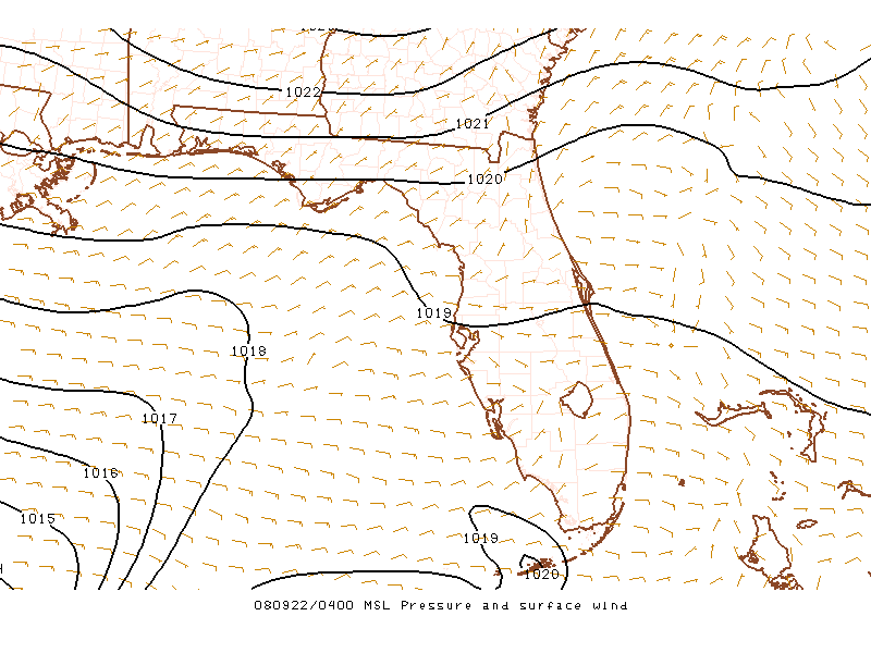
here.We'll need to keep an eye on the cloud cover situation...and various indicies...first the surface map...
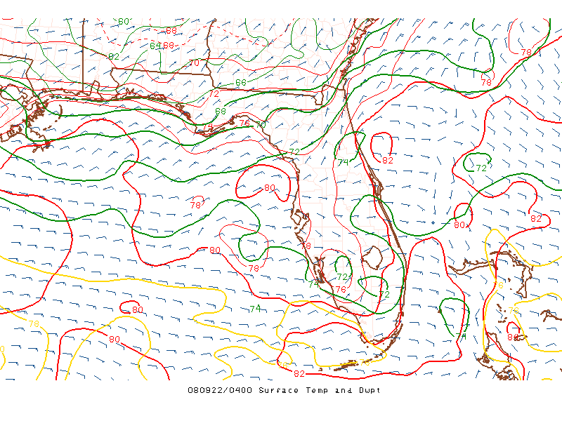
Now let's take a look at the moisture situation...
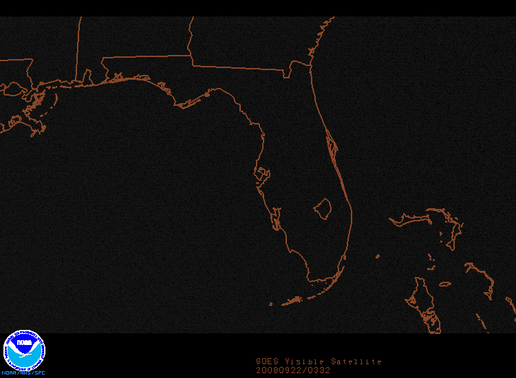
Finally the Satellite Picture...which will be the visible sector through this evening...
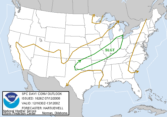
And finally the latest from SPC...parts of the area are now expectedly upgraded to moderate risk...
Again we'll elaborate more later today into this evening...it'll probably be a long night...and the daytime should be OK for the most part....very windy...the maps above should update automatically for you...it's like one stop shopping. The Satellite picture...I'm not so sure about...you may at times need to hit refresh on your browser...
More updates this afternoon or earlier as conditions warrant...also remember to check out the Pro Forecaster area for numerous index discussions...I'll elaborate more on those later today...
Joe
Apr 30, 2008 | 4:37 PM
Category:
Weather
Based on the blogs posted and comments left, I think it's fair to say that we all know we have a chance for severe weather tomorrow. There are a lot of things that must come together for us to see severe weather here in the metro...so we will have to keep a close eye on things for the next 12-24 hours. One thing that stands out that we in the weather office have discussed are dewpoints. Models have overdone them a bit, especially for tomorrow afternoon/evening...so we'll have to see if we can reach the 60s(I think low 60s are possible). Right now mid to lower 60s are working their way into southern Texas and it's only a matter of time until they work themselves northward...especially with such strong southerly winds expected to continue through at least tomorrow morning. The Storm Prediction Center has put the entire viewing area under a slight risk for severe weather for tomorrow. We could see parts of this slight risk area upgraded to moderate risk for tomorrow...so definitely something worth keeping an eye on.
Click here to see the latest outlook info.
As far as a time frame...the entire system has slowed down quite a bit, so it looks more like a late evening into overnight event for us here in the metro. By Friday morning most of the activity should be east of us here in Kansas City, however the risk shifts east through the rest of Missouri throughout the day on Friday(most likely in the form of a squall line by then).
The main thing we can expect with these storms will be large hail, straight line winds and isolated tornadoes. The better chance for tornadoes exists to our south and west where there will be better parameters in place(time of day, heating, dewpoints, placement of dry line, etc etc).
One last thing to mention(for what it's worth-and not meant to scare anyone, just make you aware)...We've been looking at forecast Skew -T for tomorrow afternoon into Friday morning. Don mentioned it this morning on air, and it hasn't changed with this afternoon's model runs...our supercell potential will be around 90-96% per the GFS and NAM, from about 00Z-06Z Friday.
We'll all be in house if need be tomorrow evening...and of course, if you do plan to go chasing, please be careful, especially after dark, since that looks to be the best time for storms for us here in the metro.
-Karli
Apr 29, 2008 | 9:44 PM
Category:
Weather
Hello, bloggers...long time no blog! Sorry about that...School Day at the K is almost ready...I have about another 40 or 50 hours of work to complete before the show in two weeks. We are on pace for a record number of students and teachers for this year' show...so anyone who is considering attending...you need to get your reservations made this week. There is a possibility we may sell out the stadium...wow!
In a few minutes, I'll be interviewing Jon Davies who is a long time storm chaser that now lives in the Kansas City area. He has written a book for middle school kids about tornado chasing, and how to do so safely. Very nicely done manual for kids who might be interested in that sort of thing. We will run that on Friday night as a part of our 30 minute weather special...airing at 9:30 pm. We also have our semi-annual round table discussion...reviewing our winter forecast...and talk a bit about the setup for storms this spring. Joe has been working on a huge Greensburg tornado piece which will also be included! So we've all been swamped with projects!
I am sure some of you are looking at Thursday...and thinking here we go! But there are several concerns I have about the setup for storms around here that may limit the severe threat for Kansas City. I'm not even completely convinced that the storms will not split around us....but I'm not ready to write them off until we see what the upper low will actually do.
The rich moisture may get derailed a bit by a secondary surface low that forms in the much hotter air over the southern pains Thursday afternoon. Our dewpoints will climb to fairly decent levels...but the quality moisture may never quite get here. The models are already overdoing the dewpoint return a bit, and that will have to be watched carefully....but the southern low may steal a lot of the low level moisture flow...before it can get here.
I also think the lead wave at the upper levels, will lift out to the north before it gets here. So Northcentral Kansas will be the beneficiaries of that energy...watch out Beloit!
The second wave arrives later Thursday night...but by then..the surface boundary will have moved to our east...and the best low level inflow..surface heating, and dewpoint pool...will be moving away....or better focused off to our southeast.
The wavelength between the departing upper wave, and the one diving into the west now is so short, that the southern end of the oncoming upper low will be forced to swing rapidly out across the south..creating a strong negative tilt to the upper storm. That would create an even stronger likelihood that we will get the dry slot Thursday night.
On Friday. the upper cold pool rotates out into the plains...and any lingering moisture could create some cold core shower/t-storm activity...but that tends to be more spotty in nature, and would be a windy and cool weather situation. I hate to even talk about low topped convection with the strong rotation under the cold pool...but that might be something we'll have to consider for Friday.
New model runs coming in now look relatively consistent with previous run...so will see how things set up tomorrow, and make a new assessment of our threats then.
Enjoy the warmer air tomorrow! The chilly stuff comes back this weekend!
Mike
Apr 27, 2008 | 3:02 PM
Category:
Weather
WEATHER SPECIAL THIS COMING FRIDAY @ 9:30 PM...I don't remember if I've mentioned this before but a lot of people are cranky with their local meteorologist. It's got to do with our
Spring, Interrupted weather as I call it now...we just can't seem to flick the switch to a real spring feel. Sure every so often we're getting to taste the warmth but then it's yanked away and I'm afraid we're going to head there again later this week...
As far as today goes...all working out. There is still a swirl of a disturbance that actually shows up if your looking closely for it in the cumulus field on the
visible pictures.It's weakening near the TOP area...but it's there...our convective temperature is 54 off the AM sounding. Here is a definition of the convective temperature from SPC...
Convective Temperature - The approximate temperature that the air near the ground must warm to in order for surface-based convection to develop, based on analysis of a sounding. See Fig. 6.
Calculation of the convective temperature involves many
assumptions, such that thunderstorms sometimes develop well before or
well after the convective temperature is reached (or may not develop at
all). However, in some cases the convective temperature is a useful
parameter for forecasting the onset of convection.
However there is not a ton of moisture in the air...and the coldest air is passing well north of here @ 500 mbs...so while present the shower chances are fleeting at best this afternoon...
Tonight will be a clear/cool one with a light SW wind...temps will initially drop and then slowly drop AM...probably into the upper 30s to near 40. Tomorrow will see a re-enforcing shot of chilly air with highs in the mid to upper 50s...
TUE AM is concerning for temps...but there is a possibility that clouds can play a role in just how cold we get...during this time of year...to get those really chilly AMs you need to be cloud free for the most part. The record for TUE is 34 in 1976...this is very doable assuming skies are clear...and some areas may see temps in the 20s on that assumption; however MT, DH, and KR will need to see whether or not some moisture @ 15-20K feet in the form of cloud cover invades the area from the NW...any clouds of significance will certainly play a role in whether we tie or break a record.
From there we moderate as a new powerful storm from the GOA moves into the western part of the country...this storm will be a doozy...take a look...
The pressure is down to 28.94"...and while we've seen stronger...for late April that's pretty good...this storm will move into the Rockies by late WED...and will start a fast warm-up...70s on WED and near if not above 80 on THU...a front of some magnitude will be sweeping into the midwest later THU...and affecting us by late THU or FRI...this front/storm will probably have a huge temp spread. With more snow on the NW side and severe storms well of towards the SE of the storm...and even the
potential of low topped supercells somewhere in the 4 state area IA/NE/MO/KS
There is some agreement, minus the GFS and GFSe that the ULL will be into central KS by FRI and slowly pull E or ENE...GFS models have the ULL about 2 states farther north. This will have major implications concerning our precip potential...farther north ala GFS...and dry slot issues come up...farther south and we could be in business for a fleeting chance of severe weather...and my feeling from so far out is that THU has the potential to be REALLY warm...to hot almost...but we'll have to see where we are with low level moisture and obviously clouds...wouldn't be surprised if the ICT area runs towards 90 with this type of set-up...but it will be a big ticket storm for the week...SPC's thoughts are below...
..DISCUSSION...
LARGE CYCLONE EVOLUTION OVER NWRN CONUS -- DISCUSSED IN MORE DETAIL
IN DAY-3 OUTLOOK...WILL DOMINATE SVR POTENTIAL THROUGH DAYS 4-8 AS
WELL. DIFFERENCES BETWEEN PROGS ARE SMALLER THAN IN PREVIOUS RUNS
AND MORE MESOSCALE IN NATURE -- SFC AND ALOFT -- THOUGH STILL
POTENTIALLY CRITICAL FOR DETERMINING MOST CONCENTRATED SVR THREAT
AREAS. DAY-4/30TH-1ST MIGHT LOOK LIKE CLIMATOLOGICALLY TYPICAL
CENTRAL/SRN PLAINS WARM FRONT AND DRYLINE SVR DAY FROM PURE PATTERN
RECOGNITION FRAMEWORK...WITH STG LEE CYCLOGENESIS LIKELY ERN CO/WRN
KS AND POTENTIAL FOR PROGRESSIVE SHORTWAVE TROUGH APCHG FROM GREAT
BASIN REGION. HOWEVER...DIURNAL EML-RELATED CINH AND QUALITY/WIDTH
OF MOISTURE RETURN PLUME BOTH MAY LIMIT COVERAGE/DURATION OF SVR
THREAT. MREF/ECMWF/UK/SPECTRAL CONSENSUS OF TIMING SFC/UPPER AIR
FEATURES SUGGESTS DAY-5/1ST-2ND AND ESPECIALLY DAY-6/2ND-3RD SHOULD
FEATURE RICHER LOW LEVEL MOISTURE...BUT OCCLUDING SFC LOW AND
PERHAPS STG COLD FRONTAL DOMINANCE TO CONVECTIVE FORCING. ATTM
DAY-5 APPEARS TO BE MOST PROBABLE PERIOD FOR WELL-ORGANIZED SVR
EVENT. BEYOND THAT...GUIDANCE DIVERGES TOO MUCH WITH BOUNDARIES AND
CHARACTER OF CENTRAL PLAINS DEEP-LAYER CYCLONE TO PUT CONFIDENCE IN
ANY SVR AREA.
So this will be the item of conversation...looks like a for sure shot of chillier air again FRI or SAT and even the possibility of frost for some next weekend...like I said at the beginning...
Spring, Interrupted.
Joe
Apr 26, 2008 | 8:24 AM
Category:
Weather
Missed a record by 1 degree this AM...record is 34 in 1907...we got to 35...@ KCI...with many areas starting the day with a little frost...especially in some low lying areas...
Weather today will be changing...especially during the afternoon...clouds to the west will quickly head our way later this AM...skies in the PM will cloud over...high to mid rather fast and showers are possible later today...esp. on the KS side which will overspread the region this evening into the overnight hours...while not prolific rains are expected...wouldn't be shocked if a few areas get over .25" out of this...even the potential for s few rumbles of thunder.
Should also mention that the freezing level above the surface will be around 4-5K feet late tonight...so IF there are any rumbles of thunder out there later tonight...not out of the question that we can get some sleet/graupel to come down from the storms...so don't be surprised...
Not surprising...to have frosts this late into April...even early May. A quick analysis of data from KCI over the last 20 years shows most years...especially in the 90s with several nights in the 30s even through the 1st 10 days of MAY...in 2005 it happened 8 times...in 1989 it happened 5 times in MAY (1-10) alone.
You can track the progress of the clouds during the day here...
More later this PM...I've got a tour group this AM then I'm heading up to Kearney to speak at the library there (Mid Continent on Platte-Clay Way @ 10AM...see some of you there)...very busy spring with appearances...somebody asked me yesterday at another appearance that I was doing if I enjoyed doing these type of things...and the answer 99.7 percent of the time is yes. If you're in this business long enough...you've done a few clunkers but overall they're a lot of fun and you get a real sense of the quantity of viewers that watch and what they remember...I still get people telling me they remember certain aspects of my wedding when we showed some clips on the news 11 years ago...amazing what our viewers will recall...
Joe
Apr 24, 2008 | 3:20 PM
Category:
Weather
Good Afternoon...
Well a lot of clouds out there...and no instability of significance to speak of due to combination of warm mid-level temperatures and the spoken for clouds...
First the visible satellite picture that should update automatically for the next few hours...
Again with warm mid-level temps at near 10K feet (the so called "cap") and no real energy moving our way...anything more than a few sprinkles is unlikely through midnight, if not afterwards for most areas south of 36 highway....here are the 700 mb temps...updated about every hour...
That's +9C air moving our way on WSW winds at that level close to 40 MPH...we may not get that warm at that level but combining that warm layer with temps in the lower 70s...just not a combination for storms at this time...
There is an upper level storm in the Rockies that will be swinging up to the NW of here...the air REALLY starts to fan out (get diffluent) later this evening...but at least for a while the best risk of anything active will be wayyyy out to the W or even WSW of here...i.e. far west KS and OK...the moderate risk by SPC is closer to Central KS...but that would be for late tonight...
Here is the latest outlook from
SPC and 2 excerpts...
The bottom line is that the cold front will have to give us more rain...that's not due in till tomorrow AM...there may be some elevated convection or somthing later this evening up to the NW...but for the metro I think at this point the better chances go up towards daybreak...
This front moving in will catch your attention...from the lower 70s today to the lower 50s, if not upper 40s, later tomorrow PM...so shorts will get you through in around daybreak but a blustery PM is likely with W/WNW winds at 15-30 MPH...and falling mid AM temperatures...with post frontal rain chances through noon or slightly later ...
Weekend is OK...another quick moving front is due in late SAT...moisture will be skimpy but there may be enough for some quick hitting showers SAT evening...heads up about the potential for some scattered frost SUN AM and even MON AM (especially of to the east)...Sunday temps may struggle to get to 60.
Another storm is possible towards the end of next week...we'll see how we do for moisture return quality....but it does look warm for the middle to end of next week...
I continue to put the finishing pieces on my special report airing on the Weather Special next FRIDAY @ 9:30...I'm not going to let the cat out of the bag till later next week...but I will promise you it's got a tremendous additional web presence and at least as of now it's close to 6 minutes long...that's actually cut down from 7 minutes believe it or not...
Next weekend I'll post 2 scripts...one the final version and another that I wish I could've aired (I'm lucky that I'm getting that much time to begin with)...you may find it interesting to see what items had to be eliminated and the process involved...MT and I just taped a web only feature concerning the report I put together and we'll have a whole page dedicated to my story...I'm excited...I've been living with this idea for awhile...one person who I talked to for my story was surprised no one else thought of my angle...hopefully the final product will be interesting to you...
Joe
Apr 23, 2008 | 2:24 PM
Category:
Weather
This afternoon we will continue to watch several storms developing around the metro. Already the Kansas side has gotten it's fair share of rain, lightning, wind and hail. I saw a report from a severe thunderstorm that moved through Cottonwood Falls earlier this afternoon. They reported winds of 60mph as well as numerous hail reports in and around that area. Most hail sizes were around one inch.
Click here to see the latest storm reports
On the Missouri side it's been pretty quite so far, but that will be changing over the next few hours. Storms will start popping up this afternoon and while some people will receive a lot of rain other might miss it all together. That is the nature of this afternoon's storms. As for this evening, the warm front will continue to lift north and we'll see an increase in coverage of rain and thunderstorms. Overnight is when we'll probably see the best chance for heavy rain(1+" in some spots)...and this threat for heavy rain will linger into early tomorrow morning.
Due to the possibility of heavy rains, a flood watch has been issued for most of the viewing area through Thursday morning.
Click here to see the latest watches/warnings
The forecast gets pretty tricky going into Thursday evening and Friday...with the possibility of severe weather either in our area or nearby. The Storm Prediction Center has already issued a moderate risk for parts of Kansas, extreme northwest Missouri and Nebraska.
Click here to see the latest severe weather outlook
The first concern with this potential for severe weather is the timing of the event. Right now it looks to be more of an evening event...sorry chasers! Also, there will be a pretty strong cap in place that will need to be overcome before things can start firing. Something to definitely keep an eye on for Thursday evening/Friday morning...but in the meantime, get ready for hit or miss showers and storms this afternoon.
Have a good rest of your Wednesday!
-Karli
Apr 22, 2008 | 2:47 PM
Category:
Weather
What a difference 12 hours makes!!! I'm sure a lot of you woke up last night to a nice thunderstorm in your neighborhood. Around 2 o'clock I had the first storm come through but the bigger one that dropped a nice amount of hail arrived around 3am for me! Thanks to everyone who sent in pictures today....some of them have been pretty impressive! Looking at the storm reports, the biggest hail reported was 1.50" in Kansas City, MO(23rd and College). 1.25" hail was reported in Kingsville, MO...and everyone had quite a bit of rain, lightning and thunder as well. In fact, downtown KC received 1.25" of rain from that round of storms. A few counties, due to the heavy rain, are still under flood warnings through Thursday evening. Due to the fact we are expecting more rain starting late Wednesday, there could be a possible extension to these watches, or new ones issued from all of the rain. Be careful out there and remember, don't drive over flooded roadways!!!
The good news is that those areas experiencing flooding will get a chance, at least temporarily, to dry out. The sun is back out and we should stay dry through at least tomorrow afternoon. That's when we'll see the front that moved through early this morning(and which will stall to our south through early Wednesday) return as a warm front late Wednesday. This front should make it's way well north of the metro, leaving us with warm temperatures, increasing return flow and a decent chance for rain all the way through Thursday. Heavy rain could fall in some spots during the Thursday/Friday time frame...some models have total rain expected fairly high(1-1.25") while others paint us with 0.25-0.50" max. Into Friday we will see a cold front make its way through, and potentially see some more stormy weather. It is still too soon to say if any will be severe, but we could at least see some strong storms in my opinion. Conditions will rapidly improve Friday evening with clearing skies and dry condtions expected to last through the majority of the upcoming weekend. Saturday looks gorgeous with mostly sunny skies and Sunday we'll see clouds increasing throughout the day, but I think the rain should hold off until late in the day(good news for all of you planning to run the Trolley Run). Temperature wise we'll see a return to the 60s for the weekend.
Enjoy the gorgeous afternoon...and if you are lucky enough to head out to the K...the game temps should remain in the 60s!!! Go Royals!
-Karli
Apr 21, 2008 | 5:09 PM
Category:
Weather
It was another nice day with temperatures soaring above 80 in some spots around the metro!!! Downtown reached 77 today, even with the clouds that were around for a good part of the day. Tonight we will see a very slow moving front push through the area...this is going to do two things. One, we'll see winds shifting directions, out of the north for tomorrow...and two, we'll see a chance for some rain/storms tonight into early tomorrow morning. Right now we have a pretty nice cap in place but if this can errode a little, the storms that do develop will have no problem becoming strong and possibly a few even becoming severe. Right now the main threat looks to be hail and damaging winds with these storms. The threat for strong to severe storms should remain in place through the night and then we'll see improving conditions as the front moves south tomorrow morning. The storm prediction center has us under a slight risk for severe weather.
To see the latest info... click here
The second half of Tuesday looks to be pretty nice...and highs should be in the 70s again, even though we'll start off with quite a few clouds around tomorrow. Dry weather will continue through Wednesday before another round of rain, which looks to be more widespread and heavier, moves in overnight Wednesday into Friday. Beyond that, this upcoming weekend looks very nice..and high temperatures will be closer to average for this time of the year(upper 60s).
In other news...I just got back from vacationing in Hawaii. I was out visiting my cousin and had an oppurtunity to do a lot of amazing things while out there. One thing that really amazed me was the wind and how every day but one of my vacation it blew hard enough that you didn't even need the AC on! The one day the wind wasn't blowing as bad we experienced "vog" as a result of the volcano that has been erupting on the big island. I googled vog and this is what I came up with courtesy of wikipedia:
Vog is a portmanteau (blended word) from the words "volcanic" and "smog," and is a volcanic smog formed when sulfur dioxide and other pollutants emitted by an erupting volcano mix with oxygen and moisture in the presence of sunlight. The term is most often applied to the island of Hawaii, where the Kilauea volcano has been erupting continuously since 1983. Kilauea emits an estimate of 2,000 tons of vog every day.
General Information
Vog is created when volcanic gases (specifically oxides of nitrogen) react with sunlight, oxygen and moisture. It is made up of a mixture of gases and aerosols, which makes it hard to study and potentially more dangerous than either on their own. Although vog has not been as extensively studied as it could be, it has been found that most of the aerosols are acidic and of a size where they can remain in the lungs where they can damage and impair their function and degrade the performance of the immune system. People who have been exposed to vog report headaches, breathing difficulties (including inducing asthma attacks), flu-like symptoms, and general lethargy. These effects are especially pronounced with children. Most studies of vog have been in areas where vog is present, and not of the effects of vog itself (in controlled conditions).
In Hawaii, vog mostly affects the western Kona coast of the Island of Hawaii, where the prevailing trade winds blow the vog to the southwest and wind patterns then blow it north up the Kona-Kohala coast. Prolonged periods of southerly Kona winds, however, can cause vog to affect the eastern side of the Island on rare occasions, and affect the entire state as well.
Comparing Vog with Smog
Vog and smog, both contain harmful chemicals that can damage the environment and the health of humans and other animals. However, they are different. Vog is a volcanic mixture that includes gases and aerosols which react with oxygen, moisture, and sunlight. Smog is formed from certain chemicals resulting from the oxidation of fuels (Sulfur dioxide), incomplete combustion of fuels (Carbon Monoxide), and the chemical union of O2 and N2 in internal combustion engines.
Vog and smog both share similarities as well, they both cause acid rain, and they are both hazardous for plants and animals (including humans) to breathe. Vog and smog both primarily contain the harmful chemical Sulfur Dioxide (SO2) which irritates the lungs. When vog and/or smog levels are high the sky will tend to look grey like the skies of Los Angeles. Once the vog/smog has cleared up, the sky will tend to have grey spots due to vog/smog trapped in the inversion layer.
Health Hazards
Vog can cause health problems that range from irritated eyes, skin and lungs. It can cause lung diseases such as asthma, lung cancer, and bronchitis. Lungs can be permanently damaged after long exposure to vog. The amount of damage depends on how much vog the lungs have been exposed to and how sensitive the lungs are. Vog can irritate the eyes, nose, skin, throat, tissues, and mucous membranes due to the vog particle’s small size. Vog can also cause acid rain, which can contaminate rainwater catchment systems.
That's about it for Monday...enjoy it everyone!
-Karli
Apr 20, 2008 | 1:42 PM
Category:
Weather
Good afternoon...cranking to a little jazz for you this early afternoon...looking at the clouds out there...they're called cirrostratus...and they're keeping our temperatures from fully being realized...not that it's a bad day or anything...far from it...SE winds temps eventually in the 70s (we're 69 as of this writing) but beggars can't be choosy when it comes to decent weather weekends...it was 1 week ago that we were tracking snowflakes in the AM hours so we've come a long way...here is the noon visible satellite picture...just clumps of passing clouds which as they move out will allow temps to make it towards the middle 70s...
Now for an explanation of these types of clouds...here is a descriptor from wikipedia...
Cirrostratus clouds are thin, generally uniform clouds, composed of ice-crystals, capable of forming halos.
When thick enough to be seen, they are whitish, usually with no
distinguishing features. When covering the whole sky and sometimes so
thin as to be hardly discernible, this may indicate a large amount of moisture in the upper atmosphere.[1] Cirrostratus clouds sometimes signal the beginning of a warm front and thus may be signs that precipitation
might follow in the next 12-24 hours. These clouds are located above
6,000m (20,000ft). Compare cirrostratus with other stratus cloud
formations at lower altitude: altostratus, nimbostratus, and low altitude stratus clouds
This afternoon I'm watching moisture down towards TX...here is the noon surface map...
The WRF is insistent on bringing 60-65 dewpoints up to us tomorrow by mid to late morning...the GFS does as well and the moisture will start to surge our way AM tonight...and I wouldn't be surprised if we get a lot of clouds tomorrow AM...
Here is a
loop of the VISIBLE clouds down towards TX...they will start to race our way overnight and tomorrow when you wake up skies may be mostly cloudy...but as you look at that satellite...you cant see the lower clouds underneath the higher ones...but they're there and it's a makes tomorrow complex in some ways...with the clouds moving in tonight temperatures will initially drop off this evening and then start to level out AM...probably in the mid 50s or so...
Tomorrow's forecast is complicated by the extent of cloud cover...some of which should break up...but we don't have a ton of mixing happening and as you can see from the meteogram...the moisture is pretty thick...
So we'll have to erode the clouds through late April sun...and limited mixing of dry air from above...20-30 kt winds @ 10K feet doesn't overly impress me...I think we'll see some breaks but it probably won't be the sunniest of days...that will limit our instability...maybe only mid-upper 60s for highs...but with any sun lower 70s are likely...so it's a trick...
Notice how the winds switch from the S to the NW by tomorrow evening...that's our front that will move in later tomorrow or as late as TUE AM...the NAM may be a bit bullish on the timing...so rain chances are there tomorrow evening through TUE AM...right now TUE PM may turn out real nice...not much of a front...temps should bounce to near 70 give or take...
WED looks quiet...but this front will belly up just to our south...remember how last WED we talked about this likely scenario...here are the 12Z GFS dewpoint forecasts for late WED and will be automatically updated for THU when the 00Z run comes out later tonight...
That moisture will eventually work back in on THU and has to turn into rain for us...the axis of highest PW will be running right on top of the state line through AR...of 1.25-1.5"...and capes get impressive off to the west of here...
We should get a good dose of rain towards the end of the week that may linger into FRI as well...but this is VERY IFFY at this point...as I mentioned yesterday...very LOW confidence forecast after WED of this week...
One of my favorite hotels is the Grand Bahama Westin...they hold the annual Bahama Hurricane Conference every year...they have one of the borderless pools that overlooks the ocean...and one of those bars in the pool...and 2 great golf courses...but I digress...here is a
link to a bunch of hurricane conference videos...haven't looked at any of them but will do so this week...one of these years I need to get to one of those...
Working for you...have a great afternoon.
Joe
Apr 19, 2008 | 12:34 PM
Category:
Weather
I really don't have much to update you on concerning the weather scenario...skies are gradually and slowly clearing from the west to the east...out to the west temperatures
are popping into the 60s and we'll make a late run to that territory later this afternoon...
Here is the
visible satellite loop of the clouds pulling away from the state line...
As far as the temperatures go...they are warming up nicely...with 50s and 60s common place out to the west of here...even as close as Topeka it's 57 as of the noon hour...so be patient...it'll get here...and it'll stick around for awhile for a change...
Only concern for tomorrow is the potential for some filtering cirrus clouds...they're showing up in the
sat pics off to the SW of here...still thinkk mid-upper 70s are likely...these will be high and thin...
Monday the clouds will be lower and more broken...so it may start mostly cloudy but then the clouds will break some and it should really remind you of a typical (for a change) mid week spring day...with higher dewpoints (somewhere in the 50s) and mild temps...mid 70s should do it...
Next cold front due in TUE AM...timing is not good for a bunch of t/storms but will maintain the chance...dewpoints of the AM look generous to me in the 60s...if thinkgs slow down another 12 hours...TUE may get interesting...but still not great...
I have some finds for you...first is the WGN site that has all their videos from their recent Fermilab Seminar...I've met Tom Skilling several times before at various conferences...he's about as nice as it gets in the business...incredibly sucessful at what he does...and very popular in the Windy City...
Here you go...make sure you're broadband on those videos...and there is a lot to go through...it'll keep you entertained for hours...there are also PDF documents that you can download as well from some of the speakers...\
That's it for today...those videos will keep you busy for a long time...thank me later ;)
Joe

