Mar 04, 2008 | 08:00 PM PST
Report This Post
Happy Tuesday...and a very nice afternoon it was! The March sun is
getting stronger, and the longer days are starting to have some
noticeable effects. We had a few locations within the metro area, that
warmed from the mid teens this morning to the mid 40s this
afternoon...with relatively little wind. This is important because
without he mixing...the cold air tends to sit undisturbed in the lower
atmosphere...tough to dislodge. But with the better sun angle...the
lower layers are actually getting a better dose of sunlight to nudge
the air temperature upward a bit more effectively.
That being said...the sun will have to work hard over the next few
days. More Arctic clipper heading our way, coupled with colder air
aloft...will give us a steady trend toward chillier air between now and
Friday. The colder air will modify a little as it heads
southward...plus there is not much snow left to our north until you get
up into South Dakota...so any sun at all will help moderate the cold.
Nevertheless...a fast moving chunk of cold air comes barreling down the
plains on Friday...and even with a partly sunny day...we will probably
remain in the 20s on Friday! Normal highs are now approaching 50...so
were talking readings some 25 degree below normal!
Precipitation is a big problem for the next couple of days. The
chances are there, as weak waves of moisture aloft interact with
rapidly moving pieces of energy. The result will be some patchy areas
of precipitation...both rain and snow...but things are moving so
quickly, that keeping a coherent area of sustained precipitation
together for very long is difficult. There looks to be a possibility of
some snow showers on Friday that could hold together long enough to
give us some minor accumulations...but that is based on today's
maps...and quite honestly, the timing, strength, and moisture available
to work with on each of theses clippers is in flux, and likely to
change as we approach the end of the week. If anything, I would not be
surprised to see the strength of the clipper weaken with time...so what
now looks like a rip roaring clipper...turns into a little less potent
system.
Every spring...when we go into this type of northwest flow
pattern...the models tend to hang onto the winter climatology a little
longer than it should. Today was a good example...the models
underestimated the warming we'd see today...and that may be the case
with the late week clippers as well. At least that is something to
consider.
I do think we'll see rapid warming beginning late Sunday into Monday.
We could approach 70 again by early next week...as another series of
Pacific waves come ashore. That will mean another round of
rain/t-storms like we had last Sunday night...setting up for Tuesday or
Wednesday of next week.
Speaking of warming...John Coleman, founder of the weather
channel...blasted the Weather Channel yesterday for their part in
promoting the alarmist attitudes over global warming! Here's a link to
his comments:
JOHN COLEMAN ON GLOBAL WARMING ALARMISM
Dr William Gray also chimed in with his idea on the subject:
DR GRAY PREDICTS GLOBAL COOLING
And finally, global temperature monitors ( these are the various
agencies who have been attempting to measure and track the global
average temperatures) have noticed a dramatic cooling trend in the
global temperatures lately:
GLOBAL TEMPERATURES ARE COOLING
Caution...don't cash in your 401K to buy carbon credits! You may need that money for your heating bills next winter!
Have a great Wednesday...and stay warm...if you can!
Mike
Mar 04, 2008 | 04:58 PM PST
Report This Post
MAJOR WEATHER ANNOUNCEMENT
TOMORROW DURING THE MORNING SHOWS
Mar 04, 2008 | 01:42 AM PST
Report This Post
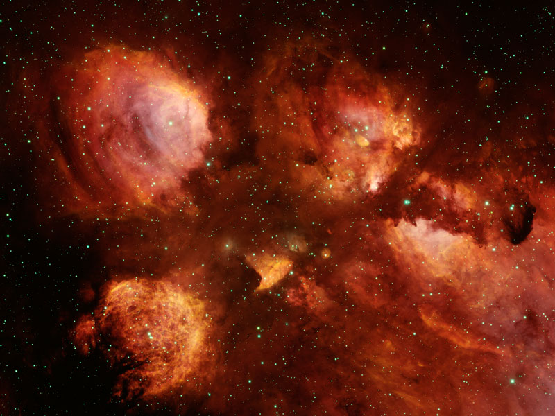
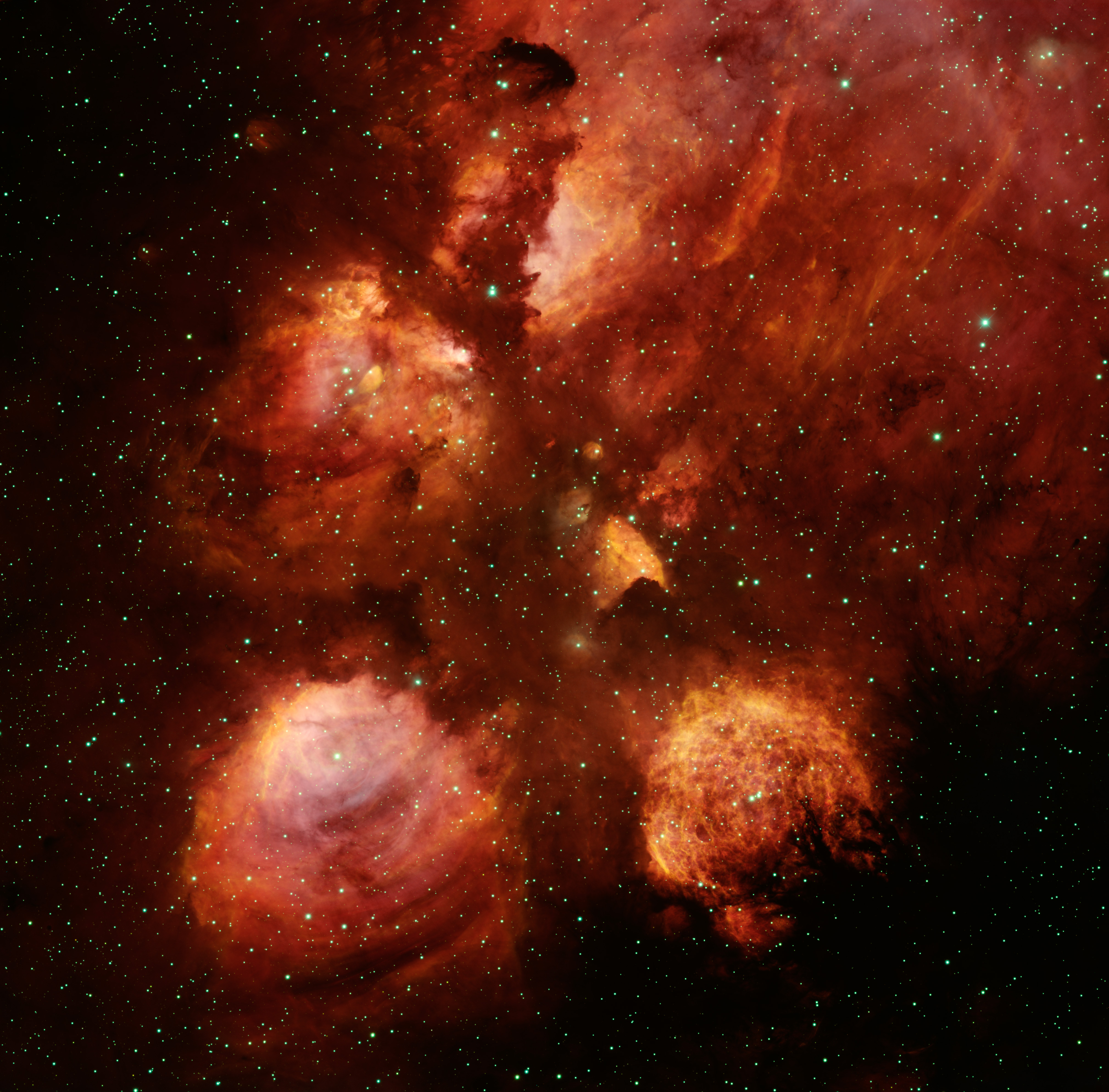
NGC 6334: The Cat's Paw Nebula Credit & Copyright: T. A. Rector (U. Alaska), T. Abbott, NOAO,
AURA,
NSF
Explanation: Nebulae are perhaps as famous for being identified with familiar shapes as perhaps cats are for getting into trouble. Still, no known cat could have created the vast Cat's Paw Nebula visible in Scorpius. At 5,500 light years distant, Cat's Paw is an emission nebula with a red color that originates from an abundance of ionized hydrogen atoms. Alternatively known as the Bear Claw Nebula or NGC 6334, stars nearly ten times the mass of our Sun have been born there in only the past few million years. Pictured above, the end of the Cat's Paw nebula was imaged from Mayall 4-Meter Telescope on Kitt Peak, Arizona, USA.
Mar 03, 2008 | 02:16 PM PST
Report This Post
Well after a rather interesting weekend...we're getting paying the piper today...temperatures are running some 40-45 degrees colder than yesterday...and when you factor in the wind chills...it's even worse...there are also some snow patches down towards the SE of the region...mainly towards Clinton and Nevada...so that even adds more insult to injury...
The major weather story for the next 24 hours...concerns the progress of the main and intesifying storm that will pull out of the state of TX and moves towards the SE MO area...this storm should spread VERY heavy snow from the I-44 corridor in SW MO all the way towards and beyond the St Louis area...but indications are that there will be (shocking I know) an extremely sharp cut-off (been there done that)...so while one county may get 6-12" of snow...2 coounties N or NW of there may get only a dusting...so forecasters will have a headache for tomorrow...there are also icing concerns for tonight...in the eastern Ozarks...so it will be a mess down there for the next 24+ hours...
I'll be using the experimental NAM for now on...I was impressed with it's performance and early heads up about various weather features for the last 3-4 days...it's going to become operational in the next few weeks I believe so might as well start using it...click for the
36 hour total precip from the storm.
The other aspect to this storm will be the
severe weather towards the gulf coast area. Tornado watches are up already down there and a moderate risk of severe storms is out for E LA most of MS and parts of AL...Central and Southern MS may really be under the gun later on...with the potential for a few strong tornadoes...unfortunately these may occur at night...
Last night I was watching my colleagues work in Oklahoma City as the city itself was placed under a tornado warning...thankfully no touchdowns in the city...it's a nice reminder to you that severe weather season can start for us at any time now...however I can tell you with confidence...that for the next 5-7 days there is no chance of severe weather...
Why...too dang cold...temperatures will be below average, perhaps significantly, from now through SAT...FRI/SAT may be nutty cold...esp FRI and FRI night as another arctic-type airmass settles in FRI AM and lingers through SAT...IF we had snowcover around I be concerned about the potential for record lows...but without the snow even with this airmass it won't be a record...but it will be cold..so gardeners don't get you hopes up for much after what we enjoyed over the weekend...
This new intrusion of cold air will suppress moisture return for awhile...hence no severe threat for us for awhile...temperatures should moderate nicely by Sunday the way it looks now...
Should also mention that there are numerous flood warnings in effect across MO...virtually every county in the SGF area is under one and many counties in this area are as well (mostly MO side). This may be a harbinger to come for the spring...on the assumption (it's a good one as far as I'm concerned) that thinks stay very active...so whether it's melted snow or torrential rainfall...it all ends up in the same place...
Rainfall amounts were rather uniform...from .80"-1.07" from the reporting stations...least I could find was .57 in Albany, MO and the highest was 1.3" om Overland Park around 87th street. In far NW MO...Tarkio had 1.4" of precip and Maryville had 2" of snow
Joe
Mar 03, 2008 | 11:03 AM PST
Report This Post
I dug this up on another board...it was written by Walt Drag...he's a NWS Meteorologist in Boston...if you've ever been interested in New England weather...read one of his Forecast Discussions...they are some of the best in the business...after you read one...you just get the feeling that he didn't miss one thing in his analysis...this concerns the Pro Forecast post a few days ago concerning the simplification/elimination of some of the winter advisories the the local offices issue...oh and I believe he's a fellow Billiken!
My description below is off duty and not a reflection of my NWS colleagues approach...
A
little background on the difficulties involved...please read and
consider not only from a user perspective but also as a forecaster...
the warning decision maker.
As a warning decision maker... we are verified as a station/then by region/and as a nation; on ALL our warnings ...
Congress sees these statistics. They=you, permit/encourage how well we develop and set our new goals/vision for improvement.
Events that we dont detect (no watch, no warning), those are not good. Also False Alarms are not favorable.
The
combination of events (in winter by zone), missed detection, or
overwarned (False Alarm) with watches and then again in warning
mode...result in a critical success index score.
Within the NWS
we have goals: The verification includes probability of detection (how
good are we at realizing an event is going to occur), false alarms
(over watching, over warning), the event hits where we got it right
according to our criteria (published for all to see), and LEAD TIME for
both the watch and warning.
Watches are permitted about a 50
percent failure. We therefore issue with about 50 percent self
calibrated confidence. Sometimes we have much greater confidence, and
other times we are issuing with 35 percent confidence. But we want
folks to start thinking about how they might change their plans if we
move to a warning, thus enhancing their life by minimizing potential
social impact. To do that...we need to think ahead of alternate plans.
Lets
say we watch 20 zones, and lets say 10 zones average the criteria and
are hits. the 10 zones may have missed... but more than likely out of
those other 10, there was probably a significant hazard that was just
under verification criteria (mixed snow and ice, both falling short of
the 12 hour 6 inch, 24 hour 8 inch, or 1/2 inch glaze value for KBOX).
We still think that is pretty decent, especially when we post watches
36 hours to sometimes 48 hours in advance. What we dont want is a 20
zone issuance, and a 20 zone miss. That gets press coverage and a lot
of complaints from commercial interests who lose business.
At 60
hours lead-time, there is still no success at reliably watching for an
event that far in advance. Witness last April 2007 when the big snows
shrunk to the high terrain and northwestward of outlooked, as the
models warmed.
Warnings: we issued with 75 percent or greater self-calibrated confidence and therefore are more careful on selecting.
You
may see us reference SREF probs, Winter Wx Impact probs..these are
artificial objective intelligence resources (yes they problems in ptype
uncertainty but are VERY good where its all snow. That helps us
calibrate our confidence, as well as other techniques (snow
dgz/banding).
The problem: we can issue a winter storm warning,
covering the gamut and describe that well in a statement. Then we
switch up to an ice storm warning in the middle of the event. Uh oh? We
switched before reaching criteria for the winter storm (now thats a
bust), and then the ice storm warning will have only 3 hours lead time,
instead of the possibly 20 hours verification lead time we would have
had with the original winter storm warning. Statistically we have lost
and what have we gained by changing title? Many people hardly
understand the difference between a watch and warning. We know media
are not pleased when their viewing area served by 2 or more WFO's has a
mix of advisories...making it a bit more difficult to explain the
differences in the precious little air time available for the media
meteorologist/presenter.
Combining the plethora of winter wx
types makes life a lot easier for us in the trenches. Our workloads are
labor intensive with gridded database editing, then applying science
based tools to predict snowfall and sometimes struggle to make these
constantly improving tools work well... ---
Its very time
consuming and with media/common wakeup-dinner time deadlines to send
products... deciding, should we go snow advisory?, winter wx advisor?
etc etc... it means we have to create the hazard for each zone... then
we have make sure it stays all snow, or all ice... and if it doesnt...
if we change, we risk null verification.
In the end we do what we think is best for the customer... but it can be confusing to have such a wide array choices.
Regardless
of what you think of NWS verification...it must be done and its
automated at HQ. We still have final say in the local offices.
For
instance: 5 inches of snow with 35 mph (that doesnt mean blizzard)
winds is a high impact event...much more difficult to control for road
crews. We would in all likelihood verify that as a warning. We can get
3/8 inch glaze with no wind and have just isolated power outages, or we
can have the same ice thickness and 25 mph gusts and power outages are
much more widespread=disruptive and that social impact plays a role in
verification.
So while we have criteria that are automatically
verified (thats why we like webentry... you enter the report, we filter
it...if it looks good and we post, it contributes to the time of the
verification), social impact can play a large role in public
perception. Five inches of snow in 3 hours during a rush hour is a much
different social impact than 5 inches of snow between midnight&3am.
This
has been a lot of words... in the end... we are frequently rushed to
get our products out... we need to simplify and let the concise written
messages drill our primary points across.
Many here may not
like this approach... but in the end...keeping it simple for mom and
dad is probably important. We dont need to get tied up in overly
specific warning headlines, when all too often we mave mixed
precipitation events, or suddenly our HSW has gone awry now that we
have 35 mph gusts pushing in on the backside (last 3-4 hours as we
approach snowfall criteria) and no longer is it just about heavy snow,
now we have drifting.
I believe Lake Effect snow warnings and other special warnings/advys will continue as in the proposal.
If
you were ever to shadow a forecast office, you'd gain more appreciation
for what is being accomplished in the NWS. Its not coffee time. We are
constantly engaged in forecasting operations that is collaborative... i
call it tethered... barely enough time to get a coffee or bag of m and
m's once or twice a shift.
Hopefully this lengthy discussion
is of some positive value in your assessment of what we are trying to
do to satisfy you with an overall best product, but at the same time
not burn ourselves out getting this job done for the overall best value
for our taxpayer investment.
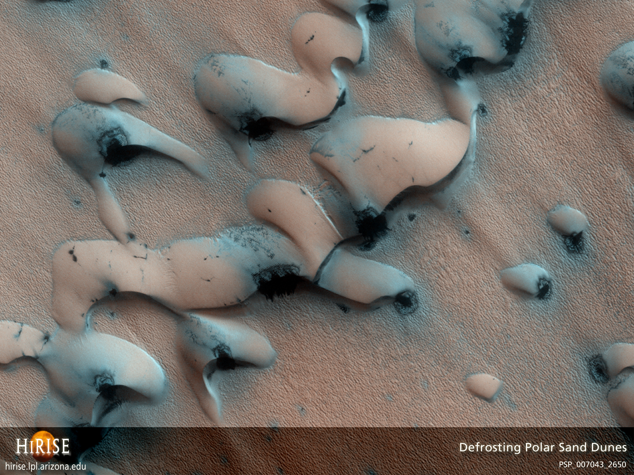
Mar 03, 2008 | 12:49 AM PST
Report This Post
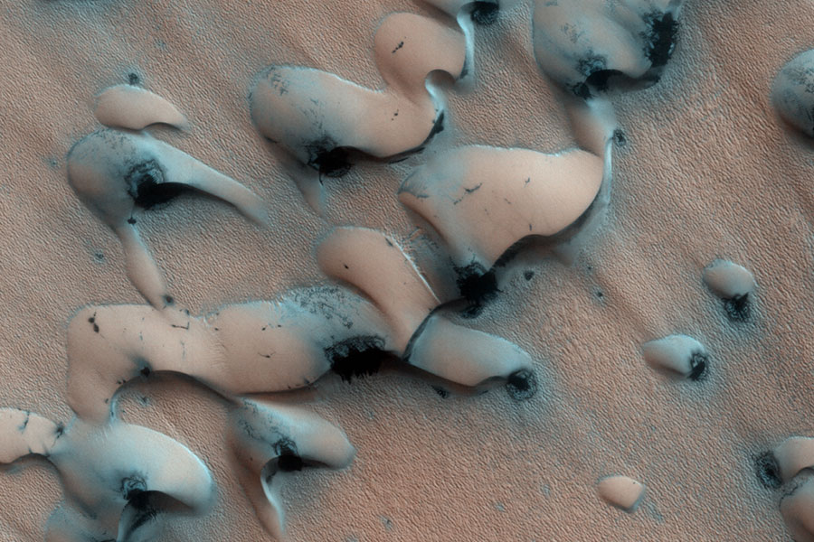
Sand Dunes Thawing on Mars Credit: HiRISE,
MRO, LPL (U. Arizona),
NASA
Explanation: What are these strange shapes on Mars? Defrosting sand dunes. As spring now dawns on the Northern Hemisphere of Mars, dunes of sand near the pole, as pictured above, are beginning to thaw. The carbon dioxide and water ice actually sublime in the thin atmosphere directly to gas. Thinner regions of ice typically defrost first revealing sand whose darkness soaks in sunlight and accelerates the thaw. The process might even involve sandy jets exploding through the thinning ice. By summer, spots will expand to encompass the entire dunes. The Martian North Pole is ringed by many similar fields of barchan sand dunes, whose strange, smooth arcs are shaped by persistent Martian winds.
Mar 02, 2008 | 09:03 PM PST
Report This Post
We are running late tonight due to NASCAR runover so latest thoughts will be on @ 9:30...
In a nutshell I'm not going to change much...will paint some accums for NW MO and NE KS...rain/snow line with a period of sleet possible before the changeover is from Maryville to north of Falls City to Concordia...again thoughts from before concerning accums are still valid...
For the metro...we'll need to get to about 34 degrees...that seems to be the magic number...also temps aloft are still way to warm now but are slowly dropping and we should get to where we need to be sometime after 1-2 AM for the metro...problem is that the bulk (heaviest) of the precip will be over with or fading fast and the temps may never get to freezing tonight...notice the upstream temps in NE...just not sticking snow cold air moving our way...
What may compensate for this to the NW of the metro is the heaviness of the snow...especially for grassy areas...still having a tough time imagining how we'll get anything of substance here in KC proper...again latest thoughts and updates on the news this evening...just got a call about snow in Alma, KS west of Topeka...
Rain is picking up now and moving in from KS...amounts should be widespread .5-1" or so especially from Sedalia/Pleasanton and N & W...some may get 1.25-1.5" if you get some thunder...there are a few rumbles out there.
Just checked with NE folks...despite the snow that's fallen...having a tough time sticking with the temps above freezing...
Joe
Mar 02, 2008 | 07:55 PM PST
Report This Post
WENT outside this evening and I swear those frogs are croaking away so spring must be getting very close for sure!
Mar 02, 2008 | 02:23 PM PST
Report This Post
Main thrust of this will be concerning severe weather...
Yesterday
we talked about this potential...and while it's not overwhelming it is
there...and my main concern as it was yesterday would be gusty winds to
60 MPH...winds now are gusting to 45 in Olathe...RUC analysis shows 850
winds continuing at 40-50 kts through 00Z...so when convection does
fire...it won't take much to get a marginal severe gust out of the
storms...the negative would be the number of storms that get going and
fighting each other for the limited instability...
Temps
have about maxed out for the metro...maybe a couple of more tacked on
towards the east of KC where there is a bit more sunshine...but the
rest of the PM should be cloudy...
Front should move in towards
dinner time...Manhattan just had FROPA and the temp dropped 20+ degrees
in a hour...this is what's coming for us...Falls City, NE also dropped
20 in an hour...NW MO here it comes...so over the next 2-6 hours temps
will drop fast from the NW to the SE...KCI is down 2 more to 68...
Concerning
changeover potential...still concerned that temps in NC/NE NE are in
the upper 30s...IF there is a changeover...probably not till around
2-3AM for the metro...earlier to the NW...and it's well NW of here
(Maryville>Hiawatha) that we may see a few inches of a slushy accum.
diminishing to the SE..for the metro tough to imagine at this point
getting much...temps will be near freezing and the ground warm...plus
should be done with by 6AM or so...so a very small window
indeed...those are my preliminary thoughts...
Just talked to one of my Pro Forecaster colleagues...we're in agreement for the most part...thanks Batman54!
More later..
SPC website
Joe
Mar 01, 2008 | 06:00 PM PST
Report This Post
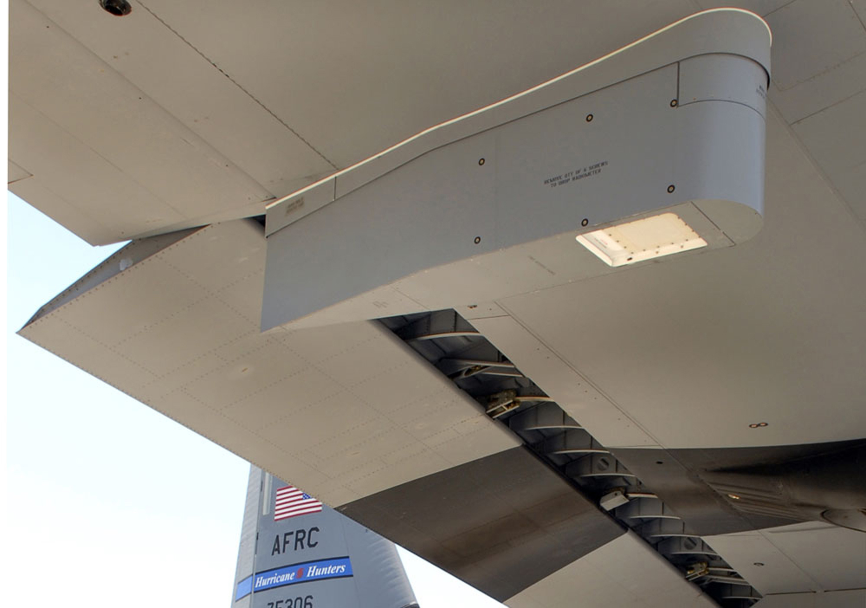
This is from NOAA...and concerns some extra well needed equipment on the recon plains sent out to check on the tropical systems that form
For the first time, America’s entire fleet of aircraft that fly
through hurricanes now have instruments that measure surface winds,
giving forecasters at NOAA’s National Hurricane Center a better view of the intensity and the size of these powerful storm systems.
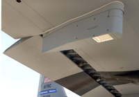
The Stepped-Frequency Microwave Radiometer continuously and accurately
measures the winds at the ocean's surface directly below this WC-130J
aricraft.
+ High Resolution (Credit: Lockheed Martin Corp.)
The
instrument, known as a stepped frequency microwave radiometer, attached
to the wing of each aircraft detects radiation that is naturally
emitted from foam created on the sea by winds at the surface. Computers
onboard the aircraft then determine surface wind speeds based on the
levels of microwave radiation detected.
"When a hurricane
threatens our coasts, key on the minds of forecasters and emergency
managers is the strength of the surface winds. With this equipment
we’ll have that information in real time,” said retired Navy Vice
Admiral Conrad C. Lautenbacher Jr., Ph.D., under secretary of commerce
for oceans and atmosphere and NOAA administrator. “Data from these
devices can improve our ability to forecast intensity changes of
tropical systems.”
In the past, aircrews extrapolated wind
speeds from the aircraft's altitude or from a GPS dropsonde released
from the aircraft. The stepped frequency microwave radiometer provides
a continuous measurement of surface winds giving NOAA’s National
Hurricane Center forecasters a more complete picture of the storm. The
instrument can also determine rainfall rates within a storm system.
This, in addition to wind speeds at flight level, provides structural
detail of the tropical cyclone.

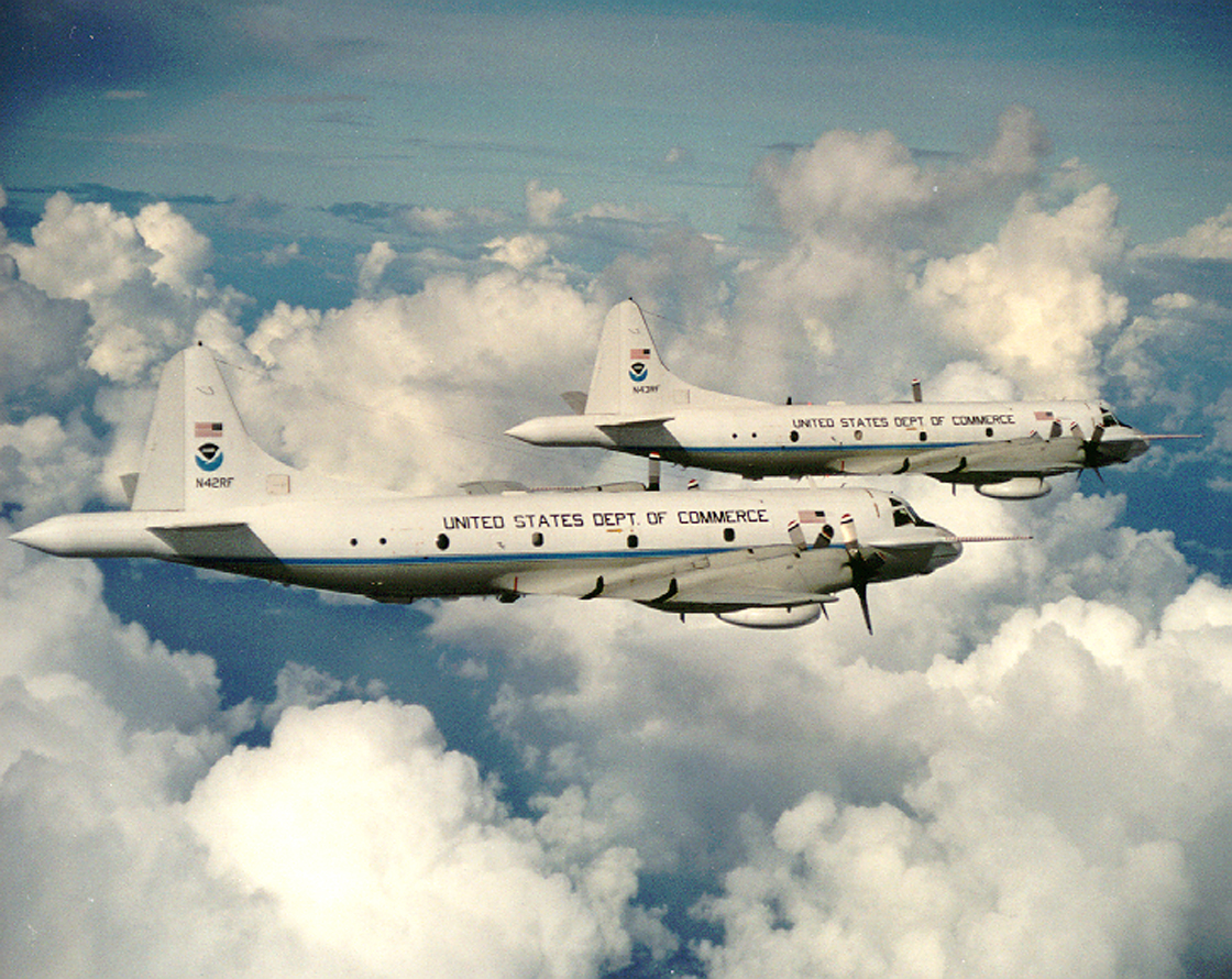
WP-3D Lockheed Orions.
+ High Resolution (Credit: Lockheed Martin Corp.)
The
current generation of this radiometer was first used on NOAA’s two
WP-3D Orion aircraft in 2003 for research flights and then used
operationally in 2005. Installation on the ten WC-130J hurricane hunter
aircraft flown by the Air Force Reserve 53rd Weather Reconnaissance Squadron began in 2006 and was just completed.
The
National Oceanic and Atmospheric Administration, an agency of the U.S.
Commerce Department, is dedicated to enhancing economic security and
national safety through the prediction and research of weather and
climate-related events and information service delivery for
transportation, and by providing environmental stewardship of our
nation's coastal and marine resources. Through the emerging Global
Earth Observation System of Systems (GEOSS),
NOAA is working with its federal partners, more than 70 countries and
the European Commission to develop a global monitoring network that is
as integrated as the planet it observes, predicts and protects.
Mar 01, 2008 | 05:50 PM PST
Report This Post
Another decent to high QPF event is on it's way to the region later tomorrow through MON AM...
This is a mess in the making...as temperatures will start dropping sometime tomorrow afternoon...near 2-4PM up across NW MO...late PM for the metro and not till early evening for areas SE of KC...again timing of our cold front along with stratus will go far in determining the max temp potential...we'll be starting, in some cases, near 55 so it sure won't take much to pop those temperatures into the upper 60s or lower 70s (record is 80)...and if there is more sunshine...some could push 75 especially for areas S/SE of KC...once the front moves through temps head downhill...probably 15-20+ degrees in an hours time...so it should be near 50 by tomorrow evening...another fascinating weather day in what has turned into a fascinating winter...especially from a temperature standpoint...
Rainfall should be prolific in some areas...regionwide I'm expecting at least .5" with .75-1.25" possible in the metro...some areas may get close to 1.5-2" if it works out.
T/Storms are possible and there is a small chance of a few isolated severe reports since the storms will be moving at 45-55 MPH by evening...esp to the SE of KC...main issues would be a wind gust to near 60 MPH...so don't be surprised if I need to stick in the weather crawl system during the race tomorrow afternoon...
Snow potential is still VERY iffy...NAM is still going nutso with QPF and temps supporting heavy, wet, slushy snowfall...much like what happened a couple of weeks ago...this time however the dynamics of the storm itself won't be cooling the atmosphere...it's the cold air pouring into the storm...my concern is that temps today in the N Plains were into the 50s. Now granted the air in MN and N IA is much colder (20s and 30s) and this may turn out to be the air we drag in here...if that's the case then we do need to watch for a wet slushy accumulation early on MON...if we drag in a mixture of some of that air and the "milder air" of the N Plains...it may not get cold enough for an accumulating snow...plus IF we're talking the daytime hours on MON...that too could negate accums with temps 32-34...again if it sounds like I'm not sure...then lets call it that...however the data tonight indicates that the folks up to the N/NW of the metro may have another accumulating slushy type snow...transition timing for KC shouldn't be till early AM MON...compared to the AM runs...total QPF is MUCH more bullish per the NAM up to the NW of KC.
I looked at the upper air reports from this evening...5K temps are near or above 50 degrees as far north as the US/Canadian border...the NAM model for 6AM tomorrow says temps will be below 0 in western NE...even in MT its +3C now...looking at the RUC...it seems to be about 50 miles slower with this dramatic chill at 5K feet in the western plains this whole thing looks very fishy to me and it's a low confidence changeover forecast...sadly I may not feel comfortable with accums till later tomorrow if I even go there...perhaps up towards NW MO/NE KS...with trailing numbers-totals towards the metro...although looking at how the model initialized with reality...it seems pretty good.
The week overall will be cooler than average...perhaps from a high temperature standpoint well below average...so enjoy the night and those SUN temps...
Joe
Mar 01, 2008 | 02:19 PM PST
Report This Post
Since today is the first day of Meteorological Spring...thought it would be handy to go back and look at the last 90 days...as we put winter to bed...and granted winter is not done yet...from a record standpoint...with the exception of snow...we close the books...
Now before you cry or moan...I never quite figured out the push of meteorological winter...I'm guessing it started more for a statistical standpoint than anything else...it's just easier to figure weather numbers when you deal with the FULL months of DEC-FEB as opposed figuring the last 10 days of DEC...all of JAN/FEB and then the first 20 days or so of MAR...but it is what it is so we'll just move on...
1st the NOAA winter forecast...this was issued back in mid NOV if I remember
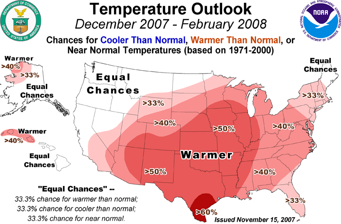
Here is how it did...
Good for the South Plains and Eastern 1/3rd of the country...miserable for the midwest, esp IA/MN/NE/KS/ and MO...this area had some of the highest chances of warmth...not so much...
Now how about precipitation...
It had the idea for the Ohio Valley and deep south...but again weak in the Rockies/Midwest area...and not good for the PAC NW (I was surprised by this area too)...
Lets get closer in...temperatures first then precip...
OK here are the way the temperatures break down...for KCI (official for KC) 2 degrees below average...for St Joseph a whopping 5 degrees below average and for Topeka about .9 degrees below average...it is shocking to see the difference between Topeka and St Joseph and I even looked again at Topeka's #'s to be sure...snowcover played a large role in this...not only at the station site but also upstream of the station as well...very interesting...
So how did I do...well let's look back to my blog on
OCTOBER 27TH...Winter 2007-2008 thoughts...Shockingly I'm sort of
excited about the snow prospects...I'm also concerned about more than
average amounts of ice as well...here is the thing that is/has been
bothering me for a few weeks...anyone notice a LACK of real Canadian
cold air...that would move our way...we're still waiting for a REAL
shot of cold air from Canada this fall...none so far...and none heading
our way till maybe the 6-8th of NOV and even that might be VERY
fleeting...that is concerning...so MUCH LOW PRESSURE up there is NEVER
a good set-up for lots of cold air forming and oozing our way
continuing our trends of warmer than average (30 year) winters...I'm expecting above average temperatures, at this point, for the winter...with prolonged periods of dryness and mildness for the season type weather...but there will be periods of back and forth...so while leaning heavily towards the warmer than average side, some decent/strong cold shots as is typical will occur my concern is that cold shots may not lock in too well particularly during the middle part of the season...
That's
also not to say we can't get some good storms...obviously at times the
pattern will block up...that should open the gates for your cold
weather...I don't think it will switch all at once...crazy warmth
followed by nasty cold for weeks on end...like last winter (mid JAN)
...to me this looks like the usual cold shots at various intervals...as
opposed to last winters total temperature reversal in the mid part of
the season (DJF). The NW part of the country and western Canada is
poised for one heck of a winter season...and as highs generate over the
snowfields in western Canada...I think they, in time, bleed our
way...my icing concerns are what happens above the surface as I think
troffing will be a big-ticket item for the western part of the
country...this will place us in SW flow aloft...which when combined
with the bleeding highs can lead to ice issues for us...now we
virtually always have 1-2 ice events in a winter...I could see maybe
2-4 events...perhaps more significant than in the past couple of
years...
Snowfall is always the
trickiest to figure out...we've yet to have a talk amongst ourselves
concerning whether we continue to forecast for KCI...(which we've done
extremely well at with these longer range forecasts) or do we broaden
things a bit more and perhaps look at the average for Pleasant
Hill...Downtown...and KCI...but then what about throwing in St Joe in
the mix...and then what about Lawrence...what about Sedalia...it
definitely muddies the waters and no doubt last year argues for the
average method. We'll discuss this internally over the next several
weeks. Right now...as mentioned earlier...I'm actually somewhat
optimistic that this can turn into a close to AVERAGE season...and
maybe with the right storms above average. Please note that I tend to
be the optimistic one concerning snowfall potential in the seasonal
outlooks. At this point I'm in the 16-21" range...last
year I think I was shooting for 17" for KCI. I can easily be
overshooting the snow totals..especially if we tack on another ice
event.
end text
We then did our video forecast about 3 weeks later if I remember...essentially none of my thoughts changed...I think I mentioned that the winter would be +2 degrees compared to average...
So from a temperature standpoint...clearly a
big miss...no two which ways about that. However some mild credit given to recognizing more cold shots would be coming (but then again it is winter)...and while they didn't per say lock in for weeks at a time...and I recognized a lack of blocking...it was cold enough that any warmer periods were VERY fleeting...I, so far, have correctly predicted the coldest temperature of the winter @ -4 @ KCI
Ice storm thoughts were good...and we'll have to see how March finishes...there were some devastating ice storms around...S MO had a couple and NW MO/NE KS had a big one...the metro had one as well that knocked out power to 100,000 people at one point...so that part was OK...
My snowfall forecast ended up at 16" I think...I recognized the potential as I mentioned to an average season...or even an above average potential...but in the end I just couldn't pull the trigger and go for it...in hindsight the highest I would've gone was 21" so even there it would've been short and this statistic is not over yet...so this will be another miss...that northern MO/NE KS snow total situation of 40-50" is remarkable...granted this area gets an additional 4-8" on average than our southern area...but this year it's running 30-40" above what our southern viewers have had...even 25" more than the folks on the far east/south side of the metro go...just amazing
Overall I've had better winter forecasts...but it's a fun experience...and again since I put myself out there in late OCT...what the heck...clearly I too was convinced that La Nina was going to overwhelm things...and it
may have in other parts of the country like off to the east/south of here...but clearly for the midwest as a whole...not so much...
More thoughts concerning the current situation...which is messy to say the least tonight...
Hope you enjoyed reading through this...
Joe
Feb 29, 2008 | 08:46 PM PST
Report This Post
Study Shows Bacteria Are Common in Snow
By RANDOLPH E. SCHMID – 1 day ago
WASHINGTON (AP) — Those beautiful snowflakes drifting out of the sky
may have a surprise inside — bacteria. Most snow and rain forms in
chilly conditions high in the sky and atmospheric scientists have long
known that, under most conditions, the moisture needs something to
cling to in order to condense.
Now, a new study shows a surprisingly large share of those so-called nucleators turn out to be bacteria that can affect plants.
"Bacteria
are by far the most active ice nuclei in nature," said Brent C.
Christner, an assistant professor of biological sciences at Louisiana
State University.
Christner and colleagues sampled snow from
Antarctica, France, Montana and the Yukon and they report their
findings in Friday's edition of the journal Science.
In some
samples as much as 85 percent of the nuclei were bacteria, Christner
said in a telephone interview. The bacteria were most common in France,
followed by Montana and the Yukon, and was even present to a lesser
degree in Antarctica.
The most common bacteria found was
Pseudomonas syringae, which can cause disease in several types of
plants including tomatoes and beans.
The study found it in 20
samples of snow from around the world and subsequent research has also
found it in summer rainfall in Louisiana.
The focus on
Pseudomonas in the past has been to try and eliminate it, Christner
said, but now that it turns out to be a major factor in encouraging
snow and rain, he wonders if that is a good idea. Would elimination of
this bacteria result in less rain or snow, or would it be replaced by
other nuclei such as soot and dust?
"The question is, are they a good guy or a bad guy," he said, "and I don't have the answer to that."
What
is clear is that Pseudomonas is effective at getting moisture in a
cloud to condense, he pointed out. Killed bacteria are even used as an
additive in snow making at ski resorts.
Which raises the
question, Christner said, of whether planting crops known to be
infected by Pseudomonas in areas experiencing drought might help
increase precipitation there by adding more nuclei to the atmosphere.
It
has been known that microbes and insects and algae blow around in the
atmosphere, Christner added, "but the atmosphere has not been
recognized as a place where things are active. That has been changing
in the last decade. In a cloud you've got water, organic carbon,"
everything necessary to support a microorganism.
Virginia K.
Walker, a biologist at Queen's University in Kingston, Ontario, Canada,
said other researchers have found bacteria serving as snow nuclei, but
had not identified it as Pseudomonas.
"It's one of those great
bacteria ... you can find them anywhere," said Walker, who was not part
of the research team. "They are really interesting."
Charles
Knight, a cloud physics expert at the National Center for Atmospheric
Research in Boulder, Colo., wasn't surprised by the finding, however.
At
relatively warm temperatures of just a few degrees below freezing,
bacteria are "remarkably effective" at attracting ice formation, said
Knight, who also was not part of the research group.
The study was supported by a Louisiana State University research grant.
In
a second paper published online by Science, researchers report that the
amount of dust blown into the tropical Pacific over the last
half-million years has varied widely between warm and cold periods.
Dust
also has important impacts on weather and climate ranging from serving
as nuclei for rain to blocking some incoming radiation from the sun,
and it also delivers minerals like iron that increase growth of
plankton in ocean areas.
Cores of seafloor sediment were taken from locations across the tropical Pacific covering a period of 500,000 years.
Researchers
led by Gisela Winckler of the Lamont-Doherty Earth Observatory of
Columbia University found that dust deposited in the ocean peaked
during cold periods and was less during warm periods. Using isotopes,
the scientists traced the dust on the western side to Asia and that on
the eastern side to South America.
They say the reasons for the
change are complex but in general it tends to be windier in cold
periods meaning more dust gets blown around.
They found that cold peaks occurred about every 100,000 years, with the last one at 20,000 years ago.
The research was supported by the National Science Foundation and the Earth Institute at Columbia University.
Feb 29, 2008 | 04:14 PM PST
Report This Post
1st a word of thanks to the folks @ the NWS in Pleasant Hill...I attended their severe weather seminar today...and it was nice visiting with them...comparing frustrations and ways to improve getting severe weather information to you...some mentioned that they regularly check in with the blog...so again my thanks to them...
Lots going on these next 3 days...including a dramatic warm-up scheduled for tomorrow...and then falling temperatures SUN PM through MON AM...with the potential for significant rainfall for areas particularly to the south of US 50 down towards the lakes and the I-44 corridor...
1st tomorrow...here is a look at the 3PM Plains map...temperatures in RED...
Tomorrow we should have a gusty SW wind...temperatures just above the surface will be near 60+ degrees...winds will be 15-25 MPH...so I'm being VERY aggressive in my forecast...ETA MOS (yes they still run it) gives us a whooping 75 degrees (record is 79 in 1992)...I'm not being that aggressive...but I'm shooting for the upper 60s for highs...IF we don't get enough mixing...which is what I'm basing this forecast on for tomorrow...lower 60s will be about as good as we can get...if we do get to my 68 forecast (I'll adjust if needed tonight)...that will be the warmest I think in 3 months!
Front approaches SUN AM...but should move through near lunch on SUN...that means there will be an opportunity to get to near 60 and then drop back to the 40-45 degree area (if not lower but late day as rain showers start to crop up...areas SE of the metro may see another 65-70 day...while far N MO may only be in the 40 degree territory...obviously an hour or two here or there will determine your local frontal timing and the PM temperatures...
Also notice on the map above the higher dewpoints in GREEN in TX...40s and 50s are sitting there and will move our way...the WRF is bringing that surface moisture up the 35 corridor tomorrow night...where as the GFS/NGM keep dewpoints near or below 45...how much of this moisture is actually realized will go a long ways in determining who gets the potential of flooding rainfall...my feeling at this point is that areas from Sedalia to Warsaw to Ft Scott and southwards have the best potential of seeing 1-2+" of rainfall...a slow moving cold front combined with a surface low...may create some real problems with run-off down there but it's important to note that this area is trending closer and closer to the I-35 corridor on the latest model runs...so let's not rule out some real issues closer to KC later on SUN...
Next trick is the amount of cold air that will ooze in SUN PM...and how quickly we can potentially see a changeover to snow later SUN night into early MON AM...this also is a big ???...because the 500/700 levels wouldn't support the heavier snows here...but instead are more hinting towards the south and or east of KC in the area outlined above...so this is still a very fluid situation...again as I mentioned yesterday...I'm not going to discount ANYTHING concerning the SUN night-MON situation...we're potentially looking at a strengthening storm moving towards and up the 44 corridor...just looking of the 18Z GFS...there is the potential of an accumulating snow from KC S & E...so this is concerning to me especially with the significant northward shift of the axis of heaviest precip...on the latest models...
After whatever happens on MON is over with...odds favor a quieter week with temperatures below average...before we start to moderate heading towards the later part of next week.
So again...for snow lovers out there...let's watch SUN night into MON...
Joe
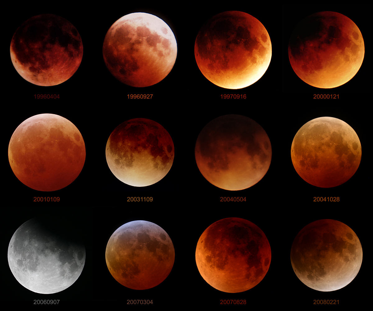
Feb 29, 2008 | 02:04 PM PST
Report This Post
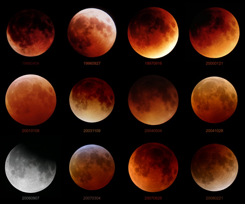
Twelve Lunar Eclipses Credit & Copyright: Tunç Tezel (
TWAN)
Explanation: Welcome to the extra day in the Gregorian Calendar's leap year 2008! To celebrate, consider this grid of lunar eclipse pictures - starting in leap year 1996 and ending with February's eclipse - with the date in numerical year/month/day format beneath each image. Mostly based on visibility from a site in Turkey, the 3x4 matrix includes 11 of the 13 total lunar eclipses during that period, and fills out the grid with the partial lunar eclipse of September 2006. Still, as the pictures are at the same scale, they illustrate a noticeable variation in the apparent size of the eclipsed Moon caused by the real change in Earth-Moon distance around the Moon's elliptical orbit. The total phases are also seen to differ in color and darkness. Those effects are due to changes in cloud cover and dust content in the atmosphere reddening and refracting sunlight into Earth's shadow. Of course, the next chance to add a total lunar eclipse to this grid will come at the very end of the decade.
Feb 28, 2008 | 06:37 PM PST
Report This Post
I stumbled across this this evening...I have NEVER been a fan of all the varied advisories that the offices had to issue...it created confusion for you and us...now apparently they're rethinking their approach...I grew up with the old Traveler's advisory...I thought that was just fine then!
Joe
FROM: ELI JACKS
CHIEF...FIRE AND PUBLIC WEATHER SERVICES BRANCH
SUBJECT: CURRENTLY SOLICITING PUBLIC COMMENTS BY APRIL 8 2008
REGARDING A PROPOSED RESTRUCTURING OF SOME NWS WINTER
WEATHER ADVISORY AND WARNING PRODUCTS
EFFECTIVE MONDAY SEPTEMBER 1 2008 AT 0001 COORDINATED UNIVERSAL
TIME /UTC/ NWS PROPOSES TO CHANGE THE SUITE OF PRODUCTS USED TO
ADVISE AND WARN PARTNERS AND THE PUBLIC OF SIGNIFICANT WINTER
WEATHER. THE PURPOSE OF THIS PROPOSED CHANGE IS TO SIMPLIFY AND
CLARIFY THE COMMUNICATION AND DISSEMINATION OF EXPECTED WINTER
WEATHER HAZARDS.
FEEDBACK FROM MANY OF OUR PARTNERS AND PUBLIC USERS OVER THE PAST
3 YEARS...COMBINED WITH INPUT FROM NWS FIELD MANAGERS AND
FORECASTERS...STRONGLY SUGGESTS SERVICE CAN BE IMPROVED BY REDUCING
THE NUMBER OF SPECIFIC WINTER WEATHER WARNING AND ADVISORY
PRODUCTS. THIS PROPOSED REDUCTION IN THE NUMBER OF PRODUCTS WOULD
ENHANCE THE CLARITY AND CONSISTENCY OF NWS WINTER WEATHER PRODUCTS.
ALSO THE GRAPHICAL DEPICTION OF FORECAST WINTER WEATHER HAZARDS VIA
THE NWS HOME PAGE AND OTHER GRAPHICAL MEANS WOULD BE MORE
UNDERSTANDABLE.
THE PROPOSED RESTRUCTURING OF NWS WINTER WEATHER PRODUCTS WOULD BE ACCOMPLISHED BY COMBINING A NUMBER OF CURRENT ADVISORY AND WARNING CATEGORIES WITH SIMILAR IMPACTS. FOR EXAMPLE...CONDITIONS THAT
CURRENTLY PROMPT THE ISSUANCE OF SEPARATE WINTER WEATHER...
SNOW...SNOW AND BLOWING SNOW...SLEET...AND/OR BLOWING SNOW
ADVISORIES WOULD BE ISSUED...AND VTEC-CODED...AS WINTER WEATHER
ADVISORIES. SIMILARLY CONDITIONS THAT CURRENTLY PROMPT THE ISSUANCE
OF SEPARATE WINTER STORM... HEAVY SNOW... AND/OR SLEET WARNINGS
WOULD BE ISSUED...AND VTEC-CODED...AS WINTER STORM WARNINGS. THE
NWS WOULD DISCONTINUE USE OF THE VTEC CODES ASSOCIATED WITH THE
DISCONTINUED ADVISORY AND WARNING PRODUCTS.
FREEZING RAIN...LAKE EFFECT SNOW...AND WIND CHILL ADVISORIES WOULD
STILL BE ISSUED DUE TO THE SEVERITY AND UNIQUENESS OF THEIR
IMPACTS. SIMILARLY...BLIZZARD...ICE STORM...LAKE EFFECT SNOW...AND
WIND CHILL WARNINGS WOULD CONTINUE TO BE ISSUED.
AS ALWAYS SPECIFIC INFORMATION RELATING TO THE TYPE OF HAZARD WOULD
BE CLEARLY DEPICTED IN THE BODY OF THE ADVISORY OR WARNING PRODUCT.
NO SOFTWARE CHANGES BY NWS PARTNERS OR USERS ARE ANTICIPATED AS A
RESULT OF THIS PROPOSED CHANGE.
HE FOLLOWING TABLES SHOW THE DIFFERENCE BETWEEN CURRENT AND
PROPOSED ADVISORY AND WARNING CATEGORIES:
TABLE 1 - WINTER ADVISORIES
CURRENT WINTER ADVISORIES PROPOSED WINTER ADVISORIES
FREEZING RAIN ------------------ FREEZING RAIN
LAKE EFFECT SNOW --------------- LAKE EFFECT SNOW
WIND CHILL --------------------- WIND CHILL
WINTER WEATHER ----------------- WINTER WEATHER
SNOW --------------------------- WINTER WEATHER
SNOW AND BLOWING SNOW ---------- WINTER WEATHER
SLEET -------------------------- WINTER WEATHER
BLOWING SNOW ------------------- WINTER WEATHER
TABLE 2 - WINTER WARNINGS
CURRENT WINTER WARNINGS PROPOSED WINTER WARNINGS
BLIZZARD ----------------------- BLIZZARD
ICE STORM ---------------------- ICE STORM
LAKE EFFECT SNOW --------------- LAKE EFFECT SNOW
WIND CHILL --------------------- WIND CHILL
WINTER STORM ------------------- WINTER STORM
HEAVY SNOW --------------------- WINTER STORM
SLEET -------------------------- WINTER STORM
A GRAPHICAL DEPICTION OF TABLES 1 AND 2 AND EXAMPLES OF HOW
ADVISORY AND WARNING PRODUCTS WILL BE FORMATTED AS A RESULT OF THIS
PROPOSED CHANGE CAN BE FOUND AT /USE LOWER CASE LETTERS/:
HTTP://WWW.WEATHER.GOV/OS/WINTER/RESOURCES/WSW_EX.PDF
THE NWS WELCOMES PARTNER AND PUBLIC COMMENTS REGARDING THIS
PROPOSED CHANGE. PLEASE SEND YOUR COMMENTS /WITH THE SUBJECT LINE:
COMMENTS ON PROPOSED WINTER WEATHER SIMPLIFICATION/ TO:
[email protected]AFTER A REVIEW OF ALL COMMENTS...THE NWS WILL DECIDE BY MAY 1 2008
WHETHER OR NOT TO IMPLEMENT THIS PROPOSED CHANGE.
FOR FURTHER INFORMATION REGARDING THIS PROPOSED CHANGE IN THE
ISSUANCE AND DISSEMINATION OF WINTER WEATHER ADVISORIES AND
WARNINGS...PLEASE CONTACT:
PAUL STOKOLS
FIRE AND PUBLIC WEATHER SERVICES BRANCH
1325 EAST WEST HIGHWAY
SILVER SPRING MD 20910
301-713-1867 EXT. 139
[email protected]OR THE WARNING COORDINATION METEOROLOGIST /WCM/ AT YOUR LOCAL
WEATHER FORECAST OFFICE.
NATIONAL PUBLIC INFORMATION STATEMENTS ARE AVAILABLE ONLINE AT
/USE LOWER CASE LETTERS/:
HTTP://WWW.NWS.NOAA.GOV/OM/NOTIF.HTM
Feb 28, 2008 | 03:54 PM PST
Report This Post
Alot of people say that our earth is gradually warming. That is true, but they are giving us the wrong reasons. Every year our universe expands, and we move 2 inches closer to the sun each year that is why we are warming, its not from Greenhouse gas and all that CROCK! Have you ever noticed that they don't say anything about this when we break record lows in the winter. That also rule's out evolution. Cause if this earth was made 600 billion years ago, the earth would be burned up by the sun! Don't say I'm crazy rite off the bat, Google it and find out this info.
Feb 28, 2008 | 03:51 PM PST
Report This Post
That's about how long we'll enjoy the moderating temperatures...good
afternoon and thanks for checking in with us...just a reminder to take
a look at the Pro Forecaster section which is becoming more and more
popular in terms of the # of hits it's receiving...which is exactly
what I thought would happen..today I reposted the information on the
Linn County, KS tornado which happened one year ago today...it was the
nations first EF4 tornado...since then there have been quite a few
more...as severe weather season approaches...there will be more local
input from some very respected severe weather meteorologists in the
region...so I'm looking forward to there thoughts...
Onto the weather...got an email the other day from somebody who wanted
to know whether a cold FEB means a cold March as well...first let's
look at the past...
Coldest FEB was 1899...
1) 1899 (-13.6 below avg)
2) 1978 (-13.5)
3) 1936 (-13.4)
4) 1979 (-12.1)
5) 1905 (-11.8)
6) 1989 (-10.2)
7) 1902 (-9.6)
8) 1929 (-9.0)
9) 1895 (-8.1)
10) 1900 (-7.8)
Now this FEB through yesterday was running 5.8 below avg and with today
and tomorrow's numbers there shouldn't be much that much of an upward
trend...a bit perhaps though...
That'll make this year the coldest FEB since 1989...but probably barely in the top 20 for coldest FEBS on record...
So let's look at 1-10 again and see what happened that March...
1) March 1899 (-8.3 below average)
2) March 1978 (-5.7)
3) March 1936 (+5.6)
4) March 1979 (-1.1)
5) March 1905 (+7.5)
6) March 1989 (+.5)
7) March 1902 (+1.5)
8) March 1929 (+4.9)
9) March 1895 (-1.1)
10) March 1900 (-2.5)
So really there is no correlation between what happens in FRB and what
happens in March...a personal though on my part is that it might be
tough to get the pattern blocked up in March as opposed to FEB because
we're transitioning seasons and things tend to be more progressive
heading towards Springtime...
By the way...I'll attempt to put together some winter 2007-8 graphics
together for the blog this weekend...Meteorological Spring starts on
SAT...snowfall wise for the 10/07-today we're 37th now...it would only
take about 5-6" for us to get in the top 20...
Snowlovers should not give up the ghost yet though...March will be an
interesting month around here and the region as a whole...all sorts of
crazy things are possible.
We'll need to keep an eye on this system for MON night into TUE
AM...while now it appears it'll track too far south...you know the
routine...especially from this far away...I personally don't rule
anything out in terms of a more northern jog...
Onto another subject...I went back over the past 5 March
months...arbitrarily picked out 15 degrees as my daily plus/minus
departure from average number for temperature extremes...and discovered
that there were 24 days with a huge positive extreme compared to
average and "only" 4 days extreme below average...and that was back in
2003.
Last March was crazy warm...we had 12 days of 15 degrees above average
or higher...that month, if memory serves, was almost 9 degrees above
average.
Cold front due on Sunday...if it's AM we're near 50-55 and
dropping...lunch time 55-60 and dropping into the 40s in the
PM...couple of hours later and we're near if not above 60 and then
dropping...either way we're in the 30s I think for MON...and with the
front coming through at a potentially later time...perhaps a bit more
rain...if it's earlier than that though...might be tough to get the
instability needed...
A lot to talk about needless to say...
Joe
Feb 28, 2008 | 02:55 PM PST
Report This Post
One year ago today...information from NWS-EAX
..Linn County, KS Experiences the First EF4 Tornado Ever Recorded...
On February 28th, 2007 a large and destructive tornado moved through Linn County, KS,
taking a near 24 mile continuous path, where it caused damage to
mainly rural areas. Although structural damage was isolated due to the
rural track of the tornado, indications of a violent tornado were
observed northwest of Blue Mound, KS where a single residence,
garage, and several farm buildings were completely destroyed. Click here for the complete story of the event.
Experts from the National Weather Service office in
Pleasant Hill, MO
conducted a storm damage survey the following day, March 1st and have
rated this tornado with a peak intensity of EF4 on the new Enhanced
Fujita Scale. This rating corresponds to wind speeds estimated to be
between 166 and 200 mph. In addition to local experts, numerous other
nationally recognized damage survey experts have also viewed the data
and have all supported a rating of EF4 for this tornado based on the
evidence available. (see www.spc.noaa.gov/faq/tornado/ef-scale.html for more information on the Enhanced Fujita Scale)
Photos
below show the impressive size of this tornado, estimated between one
quarter and one half mile in diameter. They were pulled from the video
of an off duty National Weather Service employee who was out
spotting this storm. Since the tornado occurred after dark, it was only
visible when illuminated by intermittent lightning flashes. This is why
it is so extremely important that folks take immediate action when a
tornado warning is issued. If you wait to see or hear it, it may be too
late!
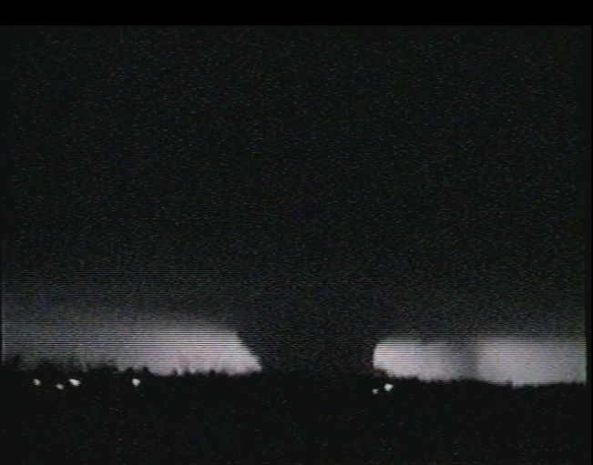
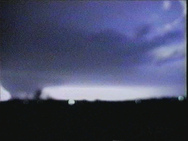 Photo Credits: Andy Fischer, Aviation Weather Center. Images may not be used without expressed written permission.
Radar
imagery shown below shows the supercell and its rotational signature
(center of both images) at about the same time as the above tornado
images. These images clearly show a “hook” structure in the
reflectivity field and a strong and tight rotational signature in the
velocity field. These are a few of the features meteorologists look for
when assessing a storm’s potential to produce tornadoes.
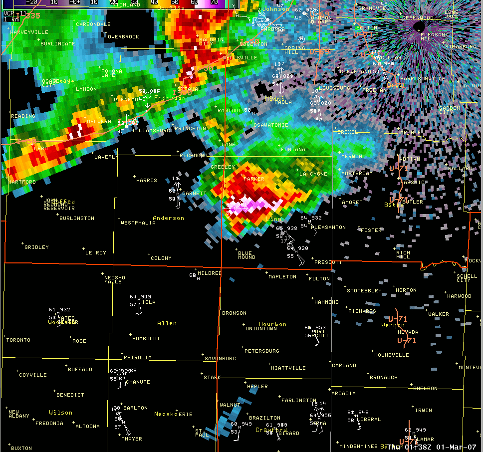
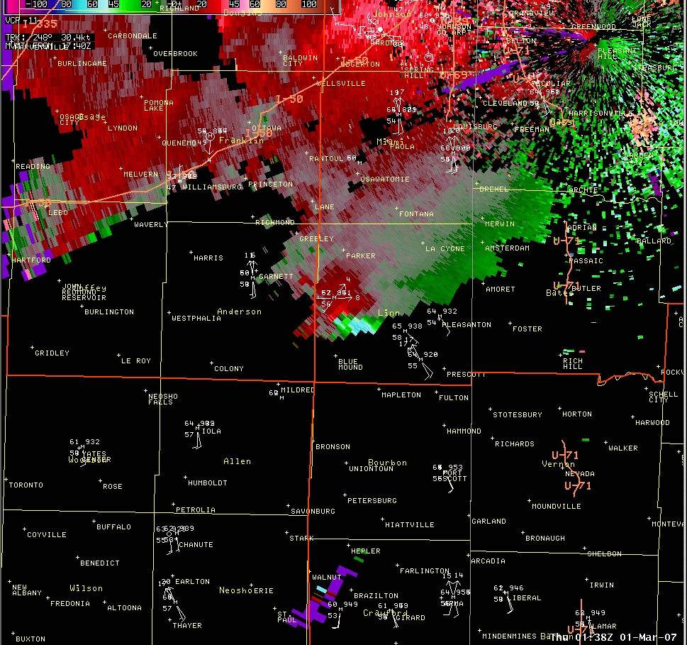
Click on Images for Larger Version
This tornado
is a historic event for a couple of reasons. First, it is the first
time anywhere in the country that a tornado has been rated as high as
EF4 since switching to the new Enhanced Fujita scale on February 1st 2007.
Second,
while tornadoes reaching EF4 intensity are rare events in their own
right, there has never been a tornado of this magnitude occurring in
Kansas this early in the year. Prior to this tornado, the earliest recorded occurrence of such a tornado in
Kansas was on March 13, 1990. Most tornadoes of this magnitude in
Kansas have occurred from late March through May.
Please see www.spc.noaa.gov/faq/tornado/ef-scale.html for more information on the Enhanced Fujita Scale.
Please see http://www.nws.noaa.gov/om/brochures/tornado.shtml<
/a> for more information on tornadoes, including important safety tips.
Feb 28, 2008 | 04:07 AM PST
Report This Post
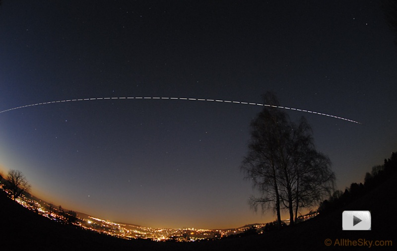
ISS: Sunlight to Shadow Credit & Copyright: Till Credner,
AlltheSky.com
Explanation: Orbiting 400,000 kilometers above the Earth, the Moon slid into Earth's shadow to begin last week's total lunar eclipse. Of course the International Space Station (ISS) slides into Earth's shadow every 90 minutes, the time it takes it to complete one orbit at an altitude of about 400 kilometers. Recorded near sunset on February 7, looking toward the north, this composite of 70 exposures shows the trail of the ISS (with gaps between exposures) as it moved left to right over the city of Tübingen in southern Germany. Beginning in sunlight on the left, the ISS vanishes as it enters Earth's shadow at the far right, above the northeastern horizon. As seen from Tübingen, the passage took about 4 minutes. Clicking on the image will download a time-lapse animation (mpg file) based on the individual exposures that includes a plane flying along the horizon.
